IMAGES TAKEN NEAR TO
Ashford Road, MAIDSTONE, ME14 4NN
Introduction
This page details the photographs taken nearby to Ashford Road, ME14 4NN by members of the Geograph project.
The Geograph project started in 2005 with the aim of publishing, organising and preserving representative images for every square kilometre of Great Britain, Ireland and the Isle of Man.

There are currently over 7.5m images from over14,400 individuals and you can help contribute to the project by visiting https://www.geograph.org.uk
Image Map (Loading...)


Getting Data...Please wait
Leaflet Map data © OpenStreetMap
Images are licensed for reuse under creativecommons.org/licenses/by-sa/2.0
Notes
- Clicking on the map will re-center to the selected point.
- The higher the marker number, the further away the image location is from the centre of the postcode.
Image Listing (9 Images Found)
Images are licensed for reuse under creativecommons.org/licenses/by-sa/2.0
Image
Details
Distance
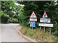
4
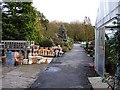
The Potted Garden
Nursery and garden centre beside the A20. This is the eastern end of the site which straddles the western edge of the grid square.
Image: © Penny Mayes
Taken: 7 Nov 2005
0.20 miles
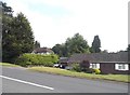
5

Grassy knoll by Ashford Road
It's become a cliche so I had to use it when appropriate. Outside the Tudor Park Marriott Hotel.
Image: © David Howard
Taken: 12 Jun 2016
0.21 miles
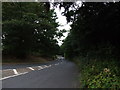
6
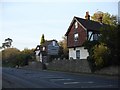
Tollgate Cottage and Tollgate House
On the north side of the A20 Ashford Road.
Image: © Penny Mayes
Taken: 14 Nov 2005
0.23 miles
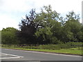
7
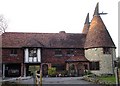
Converted oasts on Crismill Lane
The roundels are built from local ragstone.
Image: © Penny Mayes
Taken: 14 Nov 2005
0.23 miles
8
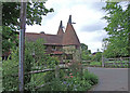
Crismill Road
Converted oasts in Crismill Road with a bridleway to the south east and a public footpath on the north east boundary.
Image: © Dennis Turner
Taken: 9 May 2009
0.23 miles