IMAGES TAKEN NEAR TO
Sandy Lane, MAIDSTONE, ME14 4JY
Introduction
This page details the photographs taken nearby to Sandy Lane, ME14 4JY by members of the Geograph project.
The Geograph project started in 2005 with the aim of publishing, organising and preserving representative images for every square kilometre of Great Britain, Ireland and the Isle of Man.

There are currently over 7.5m images from over14,400 individuals and you can help contribute to the project by visiting https://www.geograph.org.uk
Image Map
Images are licensed for reuse under creativecommons.org/licenses/by-sa/2.0
Notes
- Clicking on the map will re-center to the selected point.
- The higher the marker number, the further away the image location is from the centre of the postcode.
Image Listing (45 Images Found)
Images are licensed for reuse under creativecommons.org/licenses/by-sa/2.0
Image
Details
Distance
4
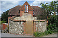
The Oast, Mount Pleasant, Bearsted, Kent
Just the lower walls of the round kiln remain.
Image: © Oast House Archive
Taken: 2 May 2009
0.06 miles
6
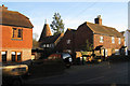
Rosemount Oast, Ware Street, Bearsted, Kent
Image: © Oast House Archive
Taken: 8 Feb 2008
0.07 miles

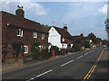
8
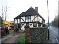
Wealden Hall House, Ware Street, Thurnham, Kent
Grade II listed.
Image: © Oast House Archive
Taken: 8 Feb 2008
0.09 miles