IMAGES TAKEN NEAR TO
Trapfield Close, MAIDSTONE, ME14 4HT
Introduction
This page details the photographs taken nearby to Trapfield Close, ME14 4HT by members of the Geograph project.
The Geograph project started in 2005 with the aim of publishing, organising and preserving representative images for every square kilometre of Great Britain, Ireland and the Isle of Man.

There are currently over 7.5m images from over14,400 individuals and you can help contribute to the project by visiting https://www.geograph.org.uk
Image Map
Images are licensed for reuse under creativecommons.org/licenses/by-sa/2.0
Notes
- Clicking on the map will re-center to the selected point.
- The higher the marker number, the further away the image location is from the centre of the postcode.
Image Listing (94 Images Found)
Images are licensed for reuse under creativecommons.org/licenses/by-sa/2.0
Image
Details
Distance
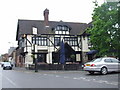
1
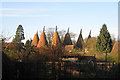
The Oasts, The Green, Bearsted, Kent
Image: © Oast House Archive
Taken: 8 Feb 2008
0.09 miles
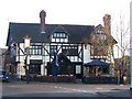
2
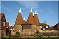
The Oasts, The Green, Bearsted, Kent
Image: © Oast House Archive
Taken: 8 Feb 2008
0.09 miles
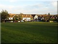
4
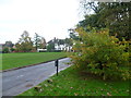
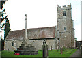
The Green at Bearsted
The Green at Bearsted is one of the most attractive in Kent. This view looks from the south side of The Green towards the houses on the east side.
Image: © Marathon
Taken: 12 Nov 2013
0.10 miles
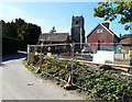
6
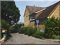
The Oak on the Green Pub, Bearsted
On junction of The Street and Yeoman Lane.
Was called the 'Walnut Tree', until 1890 and then the 'Royal Oak' until 2002. Until the hurricane of 1987, a large oak tree stood outside its front door.
Luckily, it missed the pub.
Image: © David Anstiss
Taken: 26 Dec 2008
0.10 miles
8
Redevelopment of Caterways, Church Lane, Bearsted
Planning permission has been granted by Maidstone Borough Council under application number 14/506788/FULL for the “demolition of existing house and erection of replacement 3 bedroom dwelling (Amended proposal following previous refusal 14/503970/FULl) as shown on Plan numbers 1636.IM.201, 1636.P.201, 1636.P.202, 1636.P.203, 1636.P.204. Design and Access Statement and Application Form received 23 December 2014”. The church of Holy Cross lies beyond.
Image: © John Baker
Taken: 9 Aug 2015
0.11 miles
10
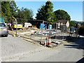
Redevelopment of Caterways, Church Lane, Bearsted
Planning permission has been granted by Maidstone Borough Council under application number 14/506788/FULL for the “demolition of existing house and erection of replacement 3 bedroom dwelling (Amended proposal following previous refusal 14/503970/FULl) as shown on Plan numbers 1636.IM.201, 1636.P.201, 1636.P.202, 1636.P.203, 1636.P.204. Design and Access Statement and Application Form received 23 December 2014”.
The site is now occupied by Image
Image: © John Baker
Taken: 9 Aug 2015
0.11 miles