IMAGES TAKEN NEAR TO
Roundwell, MAIDSTONE, ME14 4HN
Introduction
This page details the photographs taken nearby to Roundwell, ME14 4HN by members of the Geograph project.
The Geograph project started in 2005 with the aim of publishing, organising and preserving representative images for every square kilometre of Great Britain, Ireland and the Isle of Man.

There are currently over 7.5m images from over14,400 individuals and you can help contribute to the project by visiting https://www.geograph.org.uk
Image Map
Images are licensed for reuse under creativecommons.org/licenses/by-sa/2.0
Notes
- Clicking on the map will re-center to the selected point.
- The higher the marker number, the further away the image location is from the centre of the postcode.
Image Listing (54 Images Found)
Images are licensed for reuse under creativecommons.org/licenses/by-sa/2.0
Image
Details
Distance
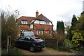
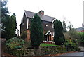
2
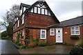
Barty House
An old manor house being redeveloped into luxury flats
Image: © N Chadwick
Taken: 29 Nov 2009
0.04 miles
4
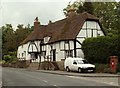
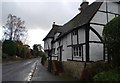
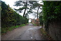
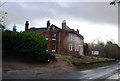
Old cottages at Bearsted
The main road here is called Roundwell and the turning just off to the right is called Sutton Street.
Image: © Robert Edwards
Taken: 12 Jun 2009
0.08 miles