IMAGES TAKEN NEAR TO
Fauchons Lane, MAIDSTONE, ME14 4AX
Introduction
This page details the photographs taken nearby to Fauchons Lane, ME14 4AX by members of the Geograph project.
The Geograph project started in 2005 with the aim of publishing, organising and preserving representative images for every square kilometre of Great Britain, Ireland and the Isle of Man.

There are currently over 7.5m images from over14,400 individuals and you can help contribute to the project by visiting https://www.geograph.org.uk
Image Map
Images are licensed for reuse under creativecommons.org/licenses/by-sa/2.0
Notes
- Clicking on the map will re-center to the selected point.
- The higher the marker number, the further away the image location is from the centre of the postcode.
Image Listing (36 Images Found)
Images are licensed for reuse under creativecommons.org/licenses/by-sa/2.0
Image
Details
Distance
5
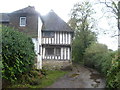
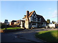
Half-timbered house at Roseacre
A footpath from Weavering Street crosses the railway line between Maidstone East and Bearsted, then drops down into a valley, and uphill on the other side to Roseacre. Just as the modern houses of Roseacre are reached this ancient house can be seen on the left.
Image: © Marathon
Taken: 12 Nov 2013
0.12 miles
6

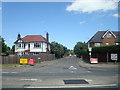
The Old Plantation Pub, Bearsted
On 33 Plantation Lane.
Image: © David Anstiss
Taken: 26 Dec 2008
0.14 miles