IMAGES TAKEN NEAR TO
Castle Hill, MAIDSTONE, ME14 3LE
Introduction
This page details the photographs taken nearby to Castle Hill, ME14 3LE by members of the Geograph project.
The Geograph project started in 2005 with the aim of publishing, organising and preserving representative images for every square kilometre of Great Britain, Ireland and the Isle of Man.

There are currently over 7.5m images from over14,400 individuals and you can help contribute to the project by visiting https://www.geograph.org.uk
Image Map
Images are licensed for reuse under creativecommons.org/licenses/by-sa/2.0
Notes
- Clicking on the map will re-center to the selected point.
- The higher the marker number, the further away the image location is from the centre of the postcode.
Image Listing (97 Images Found)
Images are licensed for reuse under creativecommons.org/licenses/by-sa/2.0
Image
Details
Distance
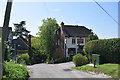
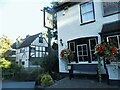
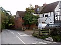
2
Castle Hill, Thurnham
Leading down to the village.
Image: © pam fray
Taken: 12 Nov 2015
0.03 miles
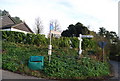
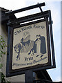

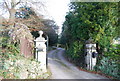
9
Rambling building next to the Black Horse inn , Detling
Half timbered and rambling. There appear to be garden-type statues inside, visible from the windows.
Image: © Bikeboy
Taken: 30 Oct 2012
0.03 miles