IMAGES TAKEN NEAR TO
Bimbury Lane, MAIDSTONE, ME14 3HX
Introduction
This page details the photographs taken nearby to Bimbury Lane, ME14 3HX by members of the Geograph project.
The Geograph project started in 2005 with the aim of publishing, organising and preserving representative images for every square kilometre of Great Britain, Ireland and the Isle of Man.

There are currently over 7.5m images from over14,400 individuals and you can help contribute to the project by visiting https://www.geograph.org.uk
Image Map
Images are licensed for reuse under creativecommons.org/licenses/by-sa/2.0
Notes
- Clicking on the map will re-center to the selected point.
- The higher the marker number, the further away the image location is from the centre of the postcode.
Image Listing (26 Images Found)
Images are licensed for reuse under creativecommons.org/licenses/by-sa/2.0
Image
Details
Distance

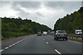
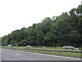
4

Loop off A249
This loop of road is a way out from the Detling Aerodrome industrial estate and also gives access to Binstead Lane.
Image: © Robin Webster
Taken: 11 Jun 2016
0.09 miles
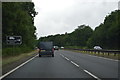
5
Sittingbourne Road
The location isn't near any large or small village
Image: © David Howard
Taken: 19 Jun 2016
0.10 miles
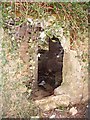
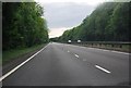
7
Pillbox on Binbury Lane
This is near the north eastern corner of what was Detling Aerodrome.
Image: © Penny Mayes
Taken: 5 Mar 2006
0.10 miles