IMAGES TAKEN NEAR TO
Scragged Oak Road, MAIDSTONE, ME14 3HB
Introduction
This page details the photographs taken nearby to Scragged Oak Road, ME14 3HB by members of the Geograph project.
The Geograph project started in 2005 with the aim of publishing, organising and preserving representative images for every square kilometre of Great Britain, Ireland and the Isle of Man.

There are currently over 7.5m images from over14,400 individuals and you can help contribute to the project by visiting https://www.geograph.org.uk
Image Map
Images are licensed for reuse under creativecommons.org/licenses/by-sa/2.0
Notes
- Clicking on the map will re-center to the selected point.
- The higher the marker number, the further away the image location is from the centre of the postcode.
Image Listing (17 Images Found)
Images are licensed for reuse under creativecommons.org/licenses/by-sa/2.0
Image
Details
Distance
1

Carousel
Kent County Show, summer 2006
Image: © Martin Smith
Taken: 16 Jul 2006
0.08 miles
2
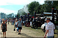
Summer steam
Kent county show ground 2006
Image: © Martin Smith
Taken: 16 Jul 2006
0.10 miles
4
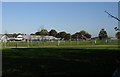
Kent County Showground
The Astor Pavilion on the left.
Image: © Penny Mayes
Taken: 27 Oct 2005
0.11 miles
6
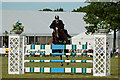
Showjumping
Kent county show ground, summer 2006
Image: © Martin Smith
Taken: 16 Jul 2006
0.15 miles
7
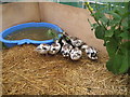
Miniature Silver Appleyard Ducks
At the Kent Show 2007.
Image: © Oast House Archive
Taken: 14 Jul 2007
0.15 miles
8
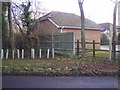
Footpath past Millfield House
(KH635) leads to A249 beside Murrain Place, from Scragged Oak Road.
Image: © David Anstiss
Taken: 5 Dec 2008
0.17 miles
9
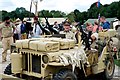
Long Range Desert Force Reinactors at Detling Show ground
Image: © Peter Skynner
Taken: 23 Aug 2014
0.17 miles
10
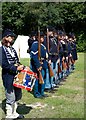
Union Cam Muster at the Detling Show Ground
Image: © Peter Skynner
Taken: 23 Aug 2014
0.17 miles