IMAGES TAKEN NEAR TO
Harbourland Close, MAIDSTONE, ME14 3DP
Introduction
This page details the photographs taken nearby to Harbourland Close, ME14 3DP by members of the Geograph project.
The Geograph project started in 2005 with the aim of publishing, organising and preserving representative images for every square kilometre of Great Britain, Ireland and the Isle of Man.

There are currently over 7.5m images from over14,400 individuals and you can help contribute to the project by visiting https://www.geograph.org.uk
Image Map
Images are licensed for reuse under creativecommons.org/licenses/by-sa/2.0
Notes
- Clicking on the map will re-center to the selected point.
- The higher the marker number, the further away the image location is from the centre of the postcode.
Image Listing (75 Images Found)
Images are licensed for reuse under creativecommons.org/licenses/by-sa/2.0
Image
Details
Distance
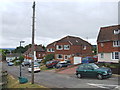
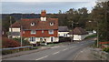
1
Harbourland Close, Harbourland, Boxley
Image: © Chris Whippet
Taken: 20 Sep 2010
0.00 miles
3

Oast House at Harbourland Farm, Boxley Road, Boxley, Kent
Single round kiln missing roof and cowl.
Image: © Oast House Archive
Taken: 14 Jun 2009
0.02 miles
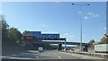
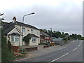
4
Boxley Road near Maidstone
The North Downs form the backdrop to this image.
Image: © Malc McDonald
Taken: 2 Nov 2013
0.02 miles
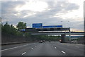
6

Southbound M20 Approaching Boxley Road Bridge
Image: © David Dixon
Taken: 15 May 2013
0.05 miles
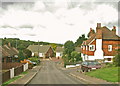
7
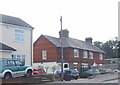
Harbourland Cottages, Harbourland, near Boxley
This row of cottages was a bit longer before the widening of the M20 in the early 1990s.
Image: © Chris Whippet
Taken: 20 Sep 2010
0.05 miles