IMAGES TAKEN NEAR TO
Gilbert Terrace, MAIDSTONE, ME14 2PR
Introduction
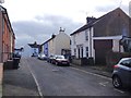
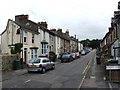
This page details the photographs taken nearby to Gilbert Terrace, ME14 2PR by members of the Geograph project.
The Geograph project started in 2005 with the aim of publishing, organising and preserving representative images for every square kilometre of Great Britain, Ireland and the Isle of Man.

There are currently over 7.5m images from over14,400 individuals and you can help contribute to the project by visiting https://www.geograph.org.uk
Image Map
Images are licensed for reuse under creativecommons.org/licenses/by-sa/2.0
Notes
- Clicking on the map will re-center to the selected point.
- The higher the marker number, the further away the image location is from the centre of the postcode.
Image Listing (14 Images Found)
Images are licensed for reuse under creativecommons.org/licenses/by-sa/2.0
Image
Details
Distance

2
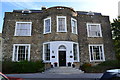
Park House, Invicta Park
Built in 1790/92, Park House was the home of the Lushington Family. Park House Estate was taken over by the Government just prior to the outbreak of the Second World War and Park House was used as a military hospital. 1964 Park House (now a listed building) became the Officers’ Mess for 36 Engineer Regiment.
Image: © Brigitt Vose
Taken: 18 Sep 2011
0.19 miles