IMAGES TAKEN NEAR TO
Mill Wood, ME14 2FW
Introduction
This page details the photographs taken nearby to Mill Wood, ME14 2FW by members of the Geograph project.
The Geograph project started in 2005 with the aim of publishing, organising and preserving representative images for every square kilometre of Great Britain, Ireland and the Isle of Man.

There are currently over 7.5m images from over14,400 individuals and you can help contribute to the project by visiting https://www.geograph.org.uk
Image Map
Images are licensed for reuse under creativecommons.org/licenses/by-sa/2.0
Notes
- Clicking on the map will re-center to the selected point.
- The higher the marker number, the further away the image location is from the centre of the postcode.
Image Listing (116 Images Found)
Images are licensed for reuse under creativecommons.org/licenses/by-sa/2.0
Image
Details
Distance
1
Old abandoned building by the River Medway
Image: © N Chadwick
Taken: 19 Sep 2009
0.06 miles
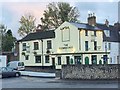
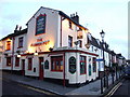
3
The Flower Pot, Maidstone
Night time in Maidstone but the Flower Pot looks welcoming. The pub serves a wide range of real ales and has won numerous CAMRA awards over the years.
Image: © Stephen McKay
Taken: 16 Oct 2017
0.07 miles
4
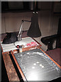
Shove Ha'penny
A game of shove ha'penny is in progress inside the Flower Pot. Although it is one of the most traditional of all pub games, boards are seldom seen nowadays. Halfpennies have been replaced by metal discs and the board is made of slate lubricated by arrowroot powder.
Image: © Stephen McKay
Taken: 16 Oct 2017
0.07 miles
6
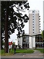
Central Library, Springfield, Maidstone
Opened in 1963 the public areas of the library are housed in the octagonal building and the link between it and the tower. The tower just straddles the northern edge of the square and holds the reserve stock. Kent County Library started its existence in the cellar of nearby Springfield Mansion http://www.geograph.org.uk/photo/179234
Image: © Penny Mayes
Taken: 15 May 2006
0.08 miles
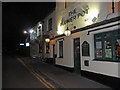
7
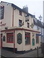
The Flower Pot Pub, Maidstone
On junction of 96 Sandling Street and Albert Street.
Image: © David Anstiss
Taken: 16 Dec 2008
0.08 miles
8
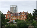
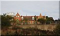
Springfield House, Maidstone
Formerly used by Kent County Council, as was the now empty tower block pictured behind.
Image: © Chris Whippet
Taken: 12 Aug 2013
0.09 miles
9
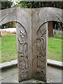
Detail of reading ring
A curious carved structure outside Image
Image: © Penny Mayes
Taken: 15 May 2006
0.09 miles