IMAGES TAKEN NEAR TO
Cromwell Road, MAIDSTONE, ME14 1EX
Introduction
This page details the photographs taken nearby to Cromwell Road, ME14 1EX by members of the Geograph project.
The Geograph project started in 2005 with the aim of publishing, organising and preserving representative images for every square kilometre of Great Britain, Ireland and the Isle of Man.

There are currently over 7.5m images from over14,400 individuals and you can help contribute to the project by visiting https://www.geograph.org.uk
Image Map
Images are licensed for reuse under creativecommons.org/licenses/by-sa/2.0
Notes
- Clicking on the map will re-center to the selected point.
- The higher the marker number, the further away the image location is from the centre of the postcode.
Image Listing (173 Images Found)
Images are licensed for reuse under creativecommons.org/licenses/by-sa/2.0
Image
Details
Distance
6
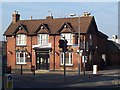
The Queen Anne Public House, Maidstone
At the junction of Union Street (on right) and A249 Albion Place (on left).
Image: © David Anstiss
Taken: 18 Mar 2009
0.08 miles
9
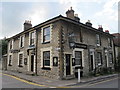
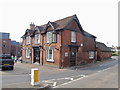
The Rifle Volunteers, Union Street / Wyatt Street, ME14
Image: © Mike Quinn
Taken: 27 Sep 2012
0.09 miles
10
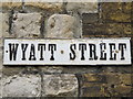
Old sign for Wyatt Street
The location of this street sign is shown in Image
Image: © Mike Quinn
Taken: 27 Sep 2012
0.09 miles