IMAGES TAKEN NEAR TO
King Street, MAIDSTONE, ME14 1DB
Introduction
This page details the photographs taken nearby to King Street, ME14 1DB by members of the Geograph project.
The Geograph project started in 2005 with the aim of publishing, organising and preserving representative images for every square kilometre of Great Britain, Ireland and the Isle of Man.

There are currently over 7.5m images from over14,400 individuals and you can help contribute to the project by visiting https://www.geograph.org.uk
Image Map
Images are licensed for reuse under creativecommons.org/licenses/by-sa/2.0
Notes
- Clicking on the map will re-center to the selected point.
- The higher the marker number, the further away the image location is from the centre of the postcode.
Image Listing (450 Images Found)
Images are licensed for reuse under creativecommons.org/licenses/by-sa/2.0
Image
Details
Distance
1
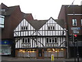
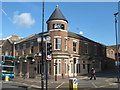
Page and Wells Estate Agent, Maidstone
Grade II listed building on 52 and 54 King Street.
See http://www.britishlistedbuildings.co.uk/en-173374-52-and-54-maidstone for more details about the building.
Image: © David Anstiss
Taken: 13 Jul 2011
0.01 miles
2

Page & Wells, 52 -54, King Street
This estate agents premises is a grade II listed, 17th century restored timber-framed building https://britishlistedbuildings.co.uk/101086324-52-and-54-king-street-maidstone#.XGr8Z_43bcc
The man on the scaffolding platform was carrying out repairs to the frontage.
Image: © John Baker
Taken: 7 Feb 2019
0.02 miles
3
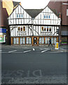
Page & Wells, 52-54, King Street
This was Image in February 2019, when repairs were being carried out to the building.
Image: © John Baker
Taken: 4 Nov 2020
0.02 miles
4
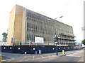
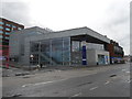
King Street Multi-Storey Car Park, Maidstone
Awaiting demolition.
Image: © Chris Whippet
Taken: 14 Jul 2013
0.02 miles
5
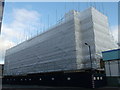
Former King's Street Multi-storey Car Park
Under the plastic cover is the former Image
The cover protects pedestrians and cars on King's Street from the demolition rubble.
The bottom floor was also a Somerfield Superstore before closing.
Image: © David Anstiss
Taken: 31 Aug 2013
0.02 miles
6
Maidstone Gateway, King Street, Maidstone
This is where Maidstone residents can access various public services. Website here http://www.maidstone.gov.uk/find-and-contact-us/the-gateway
Image: © Danny P Robinson
Taken: 29 Mar 2015
0.02 miles
7
Cream?s, 15-17, King Street
This outlet was an ice cream shop, which is now permanently closed.
Image: © John Baker
Taken: 4 Nov 2020
0.02 miles
8
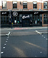
Babylon, Maidstone
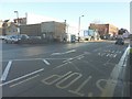
On the junction of King Street (on the left) and Church Street (on the right).
This club was once Image
Image: © David Anstiss
Taken: 7 Jun 2011
0.03 miles
9
Looking northwest along King Street
To where the redevelopment of 59 – 71, King Street is taking place. Planning permission has been granted by Maidstone Borough Council under application number 14/505005/FULL for a “redevelopment to form 53 sheltered apartments for the elderly, including communal facilities, (category 11 type accommodation) access, car parking and landscaping. The building will be known as Kings Lodge and managed by Churchill Retirement Living. It is being built on the site of the Hollywood Bowl, which I saw when I was Image in January 2014.
Image: © John Baker
Taken: 27 Nov 2016
0.03 miles
10
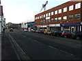
Looking east along King Street
On the left, just beyond the lamppost, is the Hollywood Bowl (Lockmeadow) at numbers 59-71; it is an entertainment centre http://hollywoodbowl.co.uk/our_centres/maidstone
Image: © John Baker
Taken: 2 Jan 2014
0.04 miles