IMAGES TAKEN NEAR TO
Burham, ROCHESTER, ME1 3YA
Introduction
This page details the photographs taken nearby to ME1 3YA by members of the Geograph project.
The Geograph project started in 2005 with the aim of publishing, organising and preserving representative images for every square kilometre of Great Britain, Ireland and the Isle of Man.

There are currently over 7.5m images from over14,400 individuals and you can help contribute to the project by visiting https://www.geograph.org.uk
Image Map
Images are licensed for reuse under creativecommons.org/licenses/by-sa/2.0
Notes
- Clicking on the map will re-center to the selected point.
- The higher the marker number, the further away the image location is from the centre of the postcode.
Image Listing (26 Images Found)
Images are licensed for reuse under creativecommons.org/licenses/by-sa/2.0
Image
Details
Distance
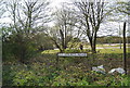
5
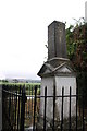
The Hawk Stone
This edifice marks the limit of the Authority of the Port of Rochester, and on it is carved, "God preserve the city of Rochester".
Image: © Jane Gilbert
Taken: 17 Jul 2010
0.10 miles
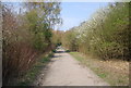
8
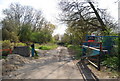
Medway Valley Walk signpost, Old Church Rd
Image: © N Chadwick
Taken: 15 Apr 2010
0.11 miles
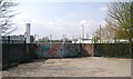
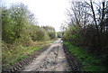
10
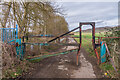
Barrier, Old Church Road
A barrier on Old Church Road south of Burham presumably designed to stop cars but allow horses and bicycles, given that this is a bridleway.
Image: © Ian Capper
Taken: 17 Feb 2022
0.12 miles