IMAGES TAKEN NEAR TO
Rochester Road, ROCHESTER, ME1 3TH
Introduction
This page details the photographs taken nearby to Rochester Road, ME1 3TH by members of the Geograph project.
The Geograph project started in 2005 with the aim of publishing, organising and preserving representative images for every square kilometre of Great Britain, Ireland and the Isle of Man.

There are currently over 7.5m images from over14,400 individuals and you can help contribute to the project by visiting https://www.geograph.org.uk
Image Map
Images are licensed for reuse under creativecommons.org/licenses/by-sa/2.0
Notes
- Clicking on the map will re-center to the selected point.
- The higher the marker number, the further away the image location is from the centre of the postcode.
Image Listing (37 Images Found)
Images are licensed for reuse under creativecommons.org/licenses/by-sa/2.0
Image
Details
Distance
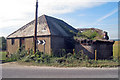
1
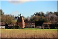
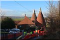
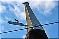
Unconverted Barn at Petts Farm
The farm house and a single square kiln oast house adjacent the barn were removed in the 1980's. The listed farmhouse was rebuilt at the Museum of Kent Life Image
There is another oast house to the left Image
Image: © Oast House Archive
Taken: 29 Sep 2009
0.02 miles
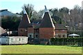
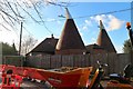
3
Unconverted Oast House at Petts Farm, Burham, Kent
Image: © Oast House Archive
Taken: 29 Sep 2009
0.04 miles