IMAGES TAKEN NEAR TO
Downs View, ROCHESTER, ME1 3RR
Introduction
This page details the photographs taken nearby to Downs View, ME1 3RR by members of the Geograph project.
The Geograph project started in 2005 with the aim of publishing, organising and preserving representative images for every square kilometre of Great Britain, Ireland and the Isle of Man.

There are currently over 7.5m images from over14,400 individuals and you can help contribute to the project by visiting https://www.geograph.org.uk
Image Map
Images are licensed for reuse under creativecommons.org/licenses/by-sa/2.0
Notes
- Clicking on the map will re-center to the selected point.
- The higher the marker number, the further away the image location is from the centre of the postcode.
Image Listing (46 Images Found)
Images are licensed for reuse under creativecommons.org/licenses/by-sa/2.0
Image
Details
Distance
4
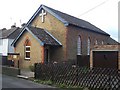
The Old Church of Burham
Methodist Church on Church Street.
For more info see http://www.kent.lovesguide.com/burham_old.htm about bell.
Or http://www.burhamvillage.com/churchburhamoldchurch.htm about church.
Image: © David Anstiss
Taken: 25 Nov 2008
0.07 miles
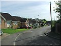
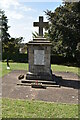
6
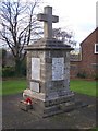
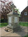
War Memorial, Burham
On junction of Rochester Road and Church Street.
In a little green square of its own.
Image: © David Anstiss
Taken: 25 Nov 2008
0.08 miles
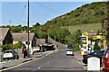
10
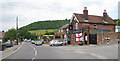
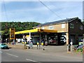
The Windmill, Burham
Looking along Rochester Road.
Image: © Oast House Archive
Taken: 21 Jun 2010
0.08 miles