IMAGES TAKEN NEAR TO
Pilgrims Way, ROCHESTER, ME1 3RB
Introduction
This page details the photographs taken nearby to Pilgrims Way, ME1 3RB by members of the Geograph project.
The Geograph project started in 2005 with the aim of publishing, organising and preserving representative images for every square kilometre of Great Britain, Ireland and the Isle of Man.

There are currently over 7.5m images from over14,400 individuals and you can help contribute to the project by visiting https://www.geograph.org.uk
Image Map
Images are licensed for reuse under creativecommons.org/licenses/by-sa/2.0
Notes
- Clicking on the map will re-center to the selected point.
- The higher the marker number, the further away the image location is from the centre of the postcode.
Image Listing (47 Images Found)
Images are licensed for reuse under creativecommons.org/licenses/by-sa/2.0
Image
Details
Distance
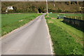
2
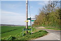
Medway Valley Walk sign, School Lane and Pilgrims Way
Image: © N Chadwick
Taken: 15 Apr 2010
0.05 miles
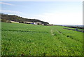
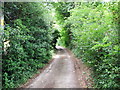
8
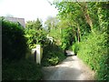
School Lane
Linking Pilgrims Way to Wouldham.
Image: © Oast House Archive
Taken: 21 Jun 2010
0.08 miles
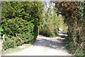
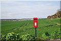
10
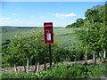
Post box on School Lane
The school is at the other end of School Lane, in Wouldham. Pilgrim's Way is to the right here and the hills in the distance are on the other side of the River Medway, around Ranscombe.
Image: © Marathon
Taken: 10 Jun 2014
0.09 miles