IMAGES TAKEN NEAR TO
Barge Walk, ROCHESTER, ME1 3FT
Introduction
This page details the photographs taken nearby to Barge Walk, ME1 3FT by members of the Geograph project.
The Geograph project started in 2005 with the aim of publishing, organising and preserving representative images for every square kilometre of Great Britain, Ireland and the Isle of Man.

There are currently over 7.5m images from over14,400 individuals and you can help contribute to the project by visiting https://www.geograph.org.uk
Image Map
Images are licensed for reuse under creativecommons.org/licenses/by-sa/2.0
Notes
- Clicking on the map will re-center to the selected point.
- The higher the marker number, the further away the image location is from the centre of the postcode.
Image Listing (85 Images Found)
Images are licensed for reuse under creativecommons.org/licenses/by-sa/2.0
Image
Details
Distance
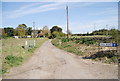
1
Peters Village Development, near Wouldham
Image: © Chris Whippet
Taken: 10 May 2015
0.02 miles
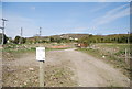
2
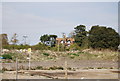
Derelict property on the Peters Village development, near Wouldham
This old house was formerly on Hall Road as were a handful of other houses demolished in May last year to make way for the new Peters Village development. Perhaps this is earmarked to be the new village's pub?
Image: © Chris Whippet
Taken: 10 May 2015
0.04 miles
3
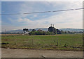
Peter's Pit
This site in the middle of a post industrial wasteland is a SSSI. The rare Great Crested Newt breeds here.
Image: © N Chadwick
Taken: 15 Apr 2010
0.04 miles
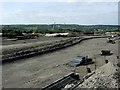
8
Tramway from Peters Pit
Peters cement plant (the "Wouldham Hall Lime & Cement Works") made cement here from around 1870 to 1928 (see www.cementkilns.co.uk/cement_kiln_peters.html ). The tramway bringing chalk (Grey Chalk and Middle Chalk) from the quarries from here went south to the lime plant and north to the cement plant washmills. At the washmills, the chalk was combined with alluvial clay from the Medway estuary to make a slurry that was fed to the kilns.
Image: © Dylan Moore
Taken: 2 Apr 2014
0.06 miles