IMAGES TAKEN NEAR TO
Village Road, ROCHESTER, ME1 3FJ
Introduction
This page details the photographs taken nearby to Village Road, ME1 3FJ by members of the Geograph project.
The Geograph project started in 2005 with the aim of publishing, organising and preserving representative images for every square kilometre of Great Britain, Ireland and the Isle of Man.

There are currently over 7.5m images from over14,400 individuals and you can help contribute to the project by visiting https://www.geograph.org.uk
Image Map
Images are licensed for reuse under creativecommons.org/licenses/by-sa/2.0
Notes
- Clicking on the map will re-center to the selected point.
- The higher the marker number, the further away the image location is from the centre of the postcode.
Image Listing (88 Images Found)
Images are licensed for reuse under creativecommons.org/licenses/by-sa/2.0
Image
Details
Distance
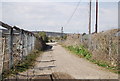
2
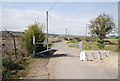
Barrier at the end of Old Church Rd
The route of the Medway Valley Walk.
Image: © N Chadwick
Taken: 15 Apr 2010
0.02 miles
4
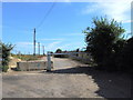
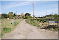
Old Church Road, near Wouldham
Leading from Hall Road to Burham Court.
Image: © Chris Whippet
Taken: 8 Jul 2010
0.03 miles
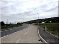
8
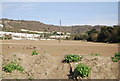
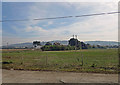
A ploughed field by Hall Rd
The old Wouldham chalk quarry can be seen in the background.
Image: © N Chadwick
Taken: 15 Apr 2010
0.04 miles