IMAGES TAKEN NEAR TO
Heron Place, ROCHESTER, ME1 3FG
Introduction
This page details the photographs taken nearby to Heron Place, ME1 3FG by members of the Geograph project.
The Geograph project started in 2005 with the aim of publishing, organising and preserving representative images for every square kilometre of Great Britain, Ireland and the Isle of Man.

There are currently over 7.5m images from over14,400 individuals and you can help contribute to the project by visiting https://www.geograph.org.uk
Image Map
Images are licensed for reuse under creativecommons.org/licenses/by-sa/2.0
Notes
- Clicking on the map will re-center to the selected point.
- The higher the marker number, the further away the image location is from the centre of the postcode.
Image Listing (85 Images Found)
Images are licensed for reuse under creativecommons.org/licenses/by-sa/2.0
Image
Details
Distance

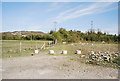
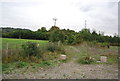
2
Path to Burham
No doubt workers at the Peters cement plant (see www.cementkilns.co.uk/cement_kiln_peters.html ) used this to walk to work.
Image: © Dylan Moore
Taken: 2 Apr 2014
0.03 miles
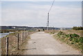
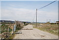
3
Tramway from Peters Pit
Peters cement plant (the "Wouldham Hall Lime & Cement Works") made cement here from around 1870 to 1928 (see www.cementkilns.co.uk/cement_kiln_peters.html ). The tramway bringing chalk (Grey Chalk and Middle Chalk) from the quarries from here went south to the lime plant and north to the cement plant washmills. At the washmills, the chalk was combined with alluvial clay from the Medway estuary to make a slurry that was fed to the kilns.
Image: © Dylan Moore
Taken: 2 Apr 2014
0.03 miles
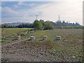
4

Village Road
The southern end of Peters Village, with Village Road running through the centre.
Image: © Ian Capper
Taken: 17 Feb 2022
0.04 miles
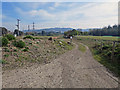
7
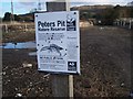
Peter's Pit Nature Reserve
On Old Church Road now trackway on Medway Valley Walk, from Wouldham to Eccles.
The pit was once a quarry used by Blue Circle Works, now flooded and habitat for newts (Ken Livingstone would love this). You can see the flooded quarry from Blue Bell Hill. Note: footpath shown on map has been diverted because of this nature reserve.
For more info see http://www.kentwildlifetrust.org.uk
Image: © David Anstiss
Taken: 25 Nov 2008
0.05 miles