IMAGES TAKEN NEAR TO
Canon Close, ROCHESTER, ME1 3EN
Introduction
This page details the photographs taken nearby to Canon Close, ME1 3EN by members of the Geograph project.
The Geograph project started in 2005 with the aim of publishing, organising and preserving representative images for every square kilometre of Great Britain, Ireland and the Isle of Man.

There are currently over 7.5m images from over14,400 individuals and you can help contribute to the project by visiting https://www.geograph.org.uk
Image Map
Images are licensed for reuse under creativecommons.org/licenses/by-sa/2.0
Notes
- Clicking on the map will re-center to the selected point.
- The higher the marker number, the further away the image location is from the centre of the postcode.
Image Listing (36 Images Found)
Images are licensed for reuse under creativecommons.org/licenses/by-sa/2.0
Image
Details
Distance
3
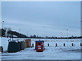
Recycling Bins, Borstal
Beside the car park of Priestfields Recreational Ground.
The rugby pitches (covered in a thick layer of snow) are in the background.
Image: © David Anstiss
Taken: 22 Jan 2013
0.08 miles
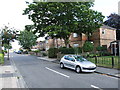
4

Sir John Fisher Church, Rochester
On Maidstone road.
Image: © David Anstiss
Taken: 20 Nov 2008
0.09 miles
5

Old Milestone by the B2097, Maidstone Road, Rochester
Carved stone post by the B2097, in parish of Rochester (Medway District), Maidstone Road, South of Priestsfields, by St John Fisher Catholic Church, back of footpath, with back to boundary wall, on West side of road. Rochester stone, erected by the Rochester & Maidstone turnpike trust in the 19th century.
Alternative view of both faces see Image
Inscription reads:-
: 1 / MILE / TO / ROCHESTER : : 7 / MILES / TO / MAIDSTONE :
Rivet benchmark on top representing 66.5m ASL.
Kent HER.
HER Number: TQ 76 NW 770 https://www.heritagegateway.org.uk/Gateway/Results_Single.aspx?uid=MKE78154&resourceID=1005
Milestone Society National ID: KE_MDRC07
Image: © C Woodward
Taken: 26 Jul 2007
0.09 miles
6

Old Milestone, B2097
Carved stone post, in parish of ROCHESTER (MEDWAY District), Maidstone Road, S of Priestsfields, by St John Fisher Catholic Church, back of footpath, with back to boundary wall, on West side of road. Rochester stone Erected by the Rochester & Maidstone turnpike trust in the 19th century.
Alternative view see Image
Inscription reads: 1 / MILE / TO / ROCHESTER / // 7 / MILES / TO / MAIDSTONE
Rivet benchmark on top representing 66.5 m ASL.
Milestone Society National ID: KE_MDRC07
Image: © Ivan Clare
Taken: Unknown
0.09 miles
7
Lilymonte Drive, Borstal
This new estate by Bellway Homes as been built along Priestfields.
Image: © David Anstiss
Taken: 22 Jan 2013
0.10 miles
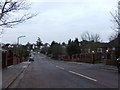
10
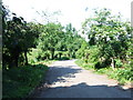
Lane leading from Priestfields towards Watts Meadow, Rochester
Image: © Chris Whippet
Taken: 14 Jun 2010
0.13 miles