IMAGES TAKEN NEAR TO
Weatherall Close, FAVERSHAM, ME13 9UL
Introduction
This page details the photographs taken nearby to Weatherall Close, ME13 9UL by members of the Geograph project.
The Geograph project started in 2005 with the aim of publishing, organising and preserving representative images for every square kilometre of Great Britain, Ireland and the Isle of Man.

There are currently over 7.5m images from over14,400 individuals and you can help contribute to the project by visiting https://www.geograph.org.uk
Image Map
Images are licensed for reuse under creativecommons.org/licenses/by-sa/2.0
Notes
- Clicking on the map will re-center to the selected point.
- The higher the marker number, the further away the image location is from the centre of the postcode.
Image Listing (22 Images Found)
Images are licensed for reuse under creativecommons.org/licenses/by-sa/2.0
Image
Details
Distance
1
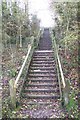
Stairs on the A2 Embankment
These stairs lead up from Dunkirk Road North, to a tunnel under the Dual Carriageway, to leads to another set of stairs down to Dunkirk Road South.
Image: © David Anstiss
Taken: 14 Nov 2009
0.09 miles
2
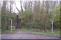
Footpath junction at the end of Dunkirk Road North
A footpath heads right to Horselees Road,along the base of an embankment. Another footpath climbs the steps up the embankment then through a tunnel under the A2 Dual Carriageway heading to Dunkirk Road South. Another path zigzags up the embankment to the tunnel (used by pushchairs etc.)
Image: © David Anstiss
Taken: 14 Nov 2009
0.09 miles
3
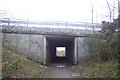
Tunnel under the A2 Dual Carriageway
This tunnel links from Dunkirk Road North to Dunkirk Road South.
Image: © David Anstiss
Taken: 14 Nov 2009
0.10 miles
5

Footpath junction on Dunkirk Road South
A footpath heads left along the base of the embankment, past Hurst Wood to Horselees Road. Another path heads up the stairs on the embankment, to a tunnel under the A2 Dual Carriageway to lead to Dunkirk Road North.
Image: © David Anstiss
Taken: 14 Nov 2009
0.12 miles
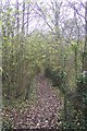
6
Footpath in Hurst Wood
This path leads from Dunkirk Road South to Horselees Wood.
Image: © David Anstiss
Taken: 14 Nov 2009
0.13 miles
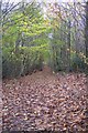
7
Footpath in Winterbourne Wood
This path leads from Dunkirk Road North up Boughton Hill to Boughton Hill road, near the Old Vicarage Farm.
Image: © David Anstiss
Taken: 14 Nov 2009
0.14 miles
8
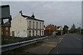
By-passed
On the old A2 through Boughton
Image: © David Long
Taken: 21 Apr 2006
0.14 miles
9
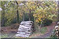
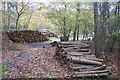
Log piles in Hurst Wood
Close to Dunkirk Road South, beside a footpath into the wood.
Image: © David Anstiss
Taken: 14 Nov 2009
0.15 miles
10
Log piles in Hurst Wood (2)
On a footpath from Horselees Road, path now nears Dunkirk Road South.
Image: © David Anstiss
Taken: 14 Nov 2009
0.15 miles