IMAGES TAKEN NEAR TO
Perry Wood, FAVERSHAM, ME13 9RU
Introduction
This page details the photographs taken nearby to Perry Wood, ME13 9RU by members of the Geograph project.
The Geograph project started in 2005 with the aim of publishing, organising and preserving representative images for every square kilometre of Great Britain, Ireland and the Isle of Man.

There are currently over 7.5m images from over14,400 individuals and you can help contribute to the project by visiting https://www.geograph.org.uk
Image Map
Images are licensed for reuse under creativecommons.org/licenses/by-sa/2.0
Notes
- Clicking on the map will re-center to the selected point.
- The higher the marker number, the further away the image location is from the centre of the postcode.
Image Listing (18 Images Found)
Images are licensed for reuse under creativecommons.org/licenses/by-sa/2.0
Image
Details
Distance
1
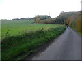
Lane near Pastures Farm
Perry Wood is straight ahead beyond the bend in the road. A footpath comes across the field on the left.
Image: © Marathon
Taken: 16 Nov 2013
0.05 miles
2
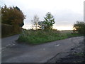
Road junction near Pastures Farm
None of these road have names. The road ahead leads to Shottenden and Chilham while the road to the right leads to Badlesmere and Sheldwich. The sun was just going down on a rather chilly and wintry afternoon.
Image: © Marathon
Taken: 16 Nov 2013
0.07 miles
3
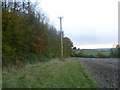
View along the edge of Perry Wood
This is the view from the same point as at http://www.geograph.org.uk/photo/3754635 but looking along the edge of the wood.
Image: © Marathon
Taken: 16 Nov 2013
0.12 miles
4
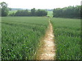
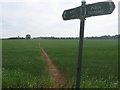
Footpath to Goldups Lane
This path leads from Grove Road, through a part of Perry Wood, then through this field to the lane.
Image: © David Anstiss
Taken: 24 Jun 2009
0.13 miles
5
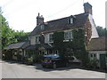
The Rose and Crown Public House, Perry Wood
On an unnamed road in Perry Wood, near Selling. See http://www.roseandcrownperrywood for more details.
Image: © David Anstiss
Taken: 24 Jun 2009
0.14 miles
6
Footpath to Fisher Street Road
This path leads from Goldups Lane, over another lane, and then onto Fisher Street Road.
Image: © David Anstiss
Taken: 24 Jun 2009
0.14 miles
7
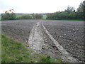
Path from Perry Wood
This path leads from Perry Wood across a rather muddy, wintry field to a lane on the other side of the trees, near Terry's Farm.
Image: © Marathon
Taken: 16 Nov 2013
0.14 miles
8
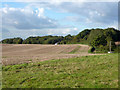
View towards Shepherds Hill
A lane to Shepherds Hill runs along the east margin of the field.
Image: © Robin Webster
Taken: 8 Oct 2015
0.17 miles
9
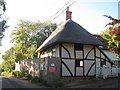
Crown Hill Cottage
Grade II listed http://list.english-heritage.org.uk/resultsingle.aspx?uid=1393183 C16 timber framed house being fully restored.
Image: © Oast House Archive
Taken: 14 Oct 2011
0.18 miles
10
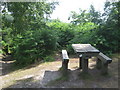
Picnic Bench in Perry Wood
This bench is on a path leading from the pub past an earthwork back to the main woodland carpark.
Image: © David Anstiss
Taken: 24 Jun 2009
0.18 miles