IMAGES TAKEN NEAR TO
Selling, FAVERSHAM, ME13 9RL
Introduction
This page details the photographs taken nearby to ME13 9RL by members of the Geograph project.
The Geograph project started in 2005 with the aim of publishing, organising and preserving representative images for every square kilometre of Great Britain, Ireland and the Isle of Man.

There are currently over 7.5m images from over14,400 individuals and you can help contribute to the project by visiting https://www.geograph.org.uk
Image Map
Images are licensed for reuse under creativecommons.org/licenses/by-sa/2.0
Notes
- Clicking on the map will re-center to the selected point.
- The higher the marker number, the further away the image location is from the centre of the postcode.
Image Listing (7 Images Found)
Images are licensed for reuse under creativecommons.org/licenses/by-sa/2.0
Image
Details
Distance
2
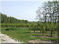
Pear orchards east of Selling
With poplar and alder windbreaks.
Image: © Jonathan Billinger
Taken: 25 Apr 2007
0.12 miles
4
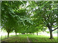
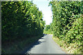
Avenue of beech trees through farmland, Selling
Public footpath north of Selling Road.
Image: © pam fray
Taken: 8 Jul 2019
0.24 miles
5
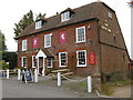
The White Lion, Selling
The village of Selling is about a mile from the station. Its pub is The White Lion, seen here looking across Selling Road.
Image: © Marathon
Taken: 23 Oct 2015
0.24 miles
6
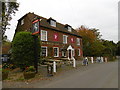
The White Lion, Selling
The village of Selling is about a mile from the station. Its pub is The White Lion, seen here looking across Selling Road.
Image: © Marathon
Taken: 23 Oct 2015
0.24 miles