IMAGES TAKEN NEAR TO
Gushmere, FAVERSHAM, ME13 9RH
Introduction
This page details the photographs taken nearby to Gushmere, ME13 9RH by members of the Geograph project.
The Geograph project started in 2005 with the aim of publishing, organising and preserving representative images for every square kilometre of Great Britain, Ireland and the Isle of Man.

There are currently over 7.5m images from over14,400 individuals and you can help contribute to the project by visiting https://www.geograph.org.uk
Image Map
Images are licensed for reuse under creativecommons.org/licenses/by-sa/2.0
Notes
- Clicking on the map will re-center to the selected point.
- The higher the marker number, the further away the image location is from the centre of the postcode.
Image Listing (7 Images Found)
Images are licensed for reuse under creativecommons.org/licenses/by-sa/2.0
Image
Details
Distance
1
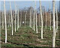
Hop Field near Selling
The field has recently been harvested.
Image: © Oast House Archive
Taken: 22 Sep 2009
0.09 miles
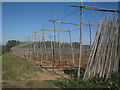
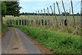
2
Hop Poles and Wires
near Neames Forstal
Image: © Peter Standing
Taken: 26 Nov 2006
0.22 miles
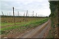
3
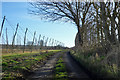
Kit Hill
One of the lesser lanes around here, missed so far by Google Street View. A hop garden is on the left.
Image: © Robin Webster
Taken: 8 Feb 2018
0.23 miles
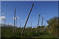
5
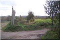
Footpath crosses Kit Hill
A footpath from Gushmere Court leads to Kit Hill then crosses straight on towards and around a hop field before crossing the railway and heading to Brenley Lane, Boughton Court.
Image: © David Anstiss
Taken: 17 Oct 2009
0.24 miles