IMAGES TAKEN NEAR TO
Hogbens Hill, FAVERSHAM, ME13 9QY
Introduction
This page details the photographs taken nearby to Hogbens Hill, ME13 9QY by members of the Geograph project.
The Geograph project started in 2005 with the aim of publishing, organising and preserving representative images for every square kilometre of Great Britain, Ireland and the Isle of Man.

There are currently over 7.5m images from over14,400 individuals and you can help contribute to the project by visiting https://www.geograph.org.uk
Image Map
Images are licensed for reuse under creativecommons.org/licenses/by-sa/2.0
Notes
- Clicking on the map will re-center to the selected point.
- The higher the marker number, the further away the image location is from the centre of the postcode.
Image Listing (18 Images Found)
Images are licensed for reuse under creativecommons.org/licenses/by-sa/2.0
Image
Details
Distance
1
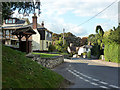
Hogben's Hill
The descent from the hill ahead is signed as 12%.
Image: © Robin Webster
Taken: 8 Oct 2015
0.04 miles
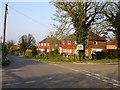
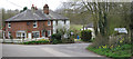
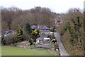
2
Selling Road, Hogben's Hill
Hogben's Hill is a sizeable community west of Selling.
Image: © Penny Mayes
Taken: 1 Apr 2007
0.05 miles
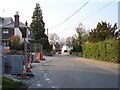
5
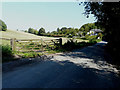
Approaching Hogben?s Hill
Along Winding Hill, which is a lane that runs from the A251 to the hamlet.
Image: © John Baker
Taken: 2 Sep 2018
0.09 miles
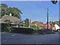
7
Houses at Featherbed Lane junction
Image: © Oast House Archive
Taken: 6 Apr 2015
0.10 miles
8
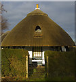
Thatch at Hogben's Hill
Cottage at the southern end of the village, seen from the public footpath from Lees Court Park
Image: © Paul Harrop
Taken: 6 Dec 2008
0.10 miles
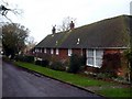
10
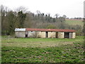
Hopper Huts
Presumed hopper huts, built around the 1950s.
Image: © Oast House Archive
Taken: 6 Apr 2015
0.14 miles