IMAGES TAKEN NEAR TO
Dunkirk Road South, FAVERSHAM, ME13 9PD
Introduction
This page details the photographs taken nearby to Dunkirk Road South, ME13 9PD by members of the Geograph project.
The Geograph project started in 2005 with the aim of publishing, organising and preserving representative images for every square kilometre of Great Britain, Ireland and the Isle of Man.

There are currently over 7.5m images from over14,400 individuals and you can help contribute to the project by visiting https://www.geograph.org.uk
Image Map
Images are licensed for reuse under creativecommons.org/licenses/by-sa/2.0
Notes
- Clicking on the map will re-center to the selected point.
- The higher the marker number, the further away the image location is from the centre of the postcode.
Image Listing (19 Images Found)
Images are licensed for reuse under creativecommons.org/licenses/by-sa/2.0
Image
Details
Distance
1
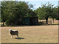
Sheep at Winterbourne
This sheep was alone in the field, though there were others in the orchard beyond.
Image: © Stephen Craven
Taken: 31 Aug 2009
0.04 miles
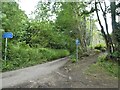
2
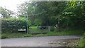
Dunkirk Road
Rural road in Kent countryside.
Image: © James Emmans
Taken: 10 Jun 2014
0.07 miles
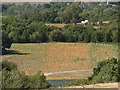
3

Secluded meadow
A secluded and presumably private meadow at Winterbourne, glimpsed from an adjacent public footpath.
Image: © Stephen Craven
Taken: 31 Aug 2009
0.12 miles
4
Pumpkin field?
I was not close enough to see, and the photo not high enough resolution to be sure, but I think these are pumpkins growing in a field at Winterbourne, Kent.
Image: © Stephen Craven
Taken: 31 Aug 2009
0.14 miles
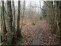
5
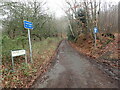
Snake Lane
The narrow Snake Lane passes through woodland and connects Horselees Road with Dunkirk Road.
Image: © Marathon
Taken: 26 Jan 2023
0.14 miles
6
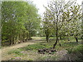
Iron Hill
A footpath makes its way north along the woodland edge of this old orchard.
Image: © Jonathan Billinger
Taken: 25 Apr 2007
0.15 miles
8
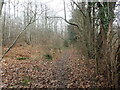
Footpath into Hurst Wood
There appears to be active coppicing going on in Hurst Wood. The wood slopes up to Iron Hill on the left. This view is from near the entrance to the wood on Hickmans Green.
Image: © Marathon
Taken: 26 Jan 2023
0.17 miles
9
Footpath into Hurst Wood
There appears to be active coppicing going on in Hurst Wood. The wood slopes up to Iron Hill on the left. This view is from near the entrance to the wood on Hickmans Green.
Image: © Marathon
Taken: 26 Jan 2023
0.17 miles
10

The Winter Bourne?
I expect that this seasonally dry stream (bourne) gave the adjacent hamlet of Winterbourne its name.
Image: © Stephen Craven
Taken: 31 Aug 2009
0.17 miles