IMAGES TAKEN NEAR TO
Hickmans Green, FAVERSHAM, ME13 9NT
Introduction
This page details the photographs taken nearby to Hickmans Green, ME13 9NT by members of the Geograph project.
The Geograph project started in 2005 with the aim of publishing, organising and preserving representative images for every square kilometre of Great Britain, Ireland and the Isle of Man.

There are currently over 7.5m images from over14,400 individuals and you can help contribute to the project by visiting https://www.geograph.org.uk
Image Map
Images are licensed for reuse under creativecommons.org/licenses/by-sa/2.0
Notes
- Clicking on the map will re-center to the selected point.
- The higher the marker number, the further away the image location is from the centre of the postcode.
Image Listing (33 Images Found)
Images are licensed for reuse under creativecommons.org/licenses/by-sa/2.0
Image
Details
Distance
1
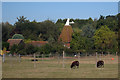
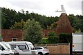
Blean Oast, Hickmans Green, Boughton-under-blean, Kent
Image: © Oast House Archive
Taken: 22 Sep 2009
0.02 miles
2
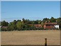
Buildings at Hickmans Green
Some of the several buildings, including a (former?) oast house, making up the property at Hickmans Green, viewed from Brickfield Lane.
Image: © Stephen Craven
Taken: 31 Aug 2009
0.02 miles
5
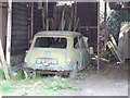
Sad sight
This 1964 Mini has seen much better days!
Image: © Jonathan Billinger
Taken: 25 Apr 2007
0.07 miles
7
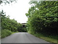
Horselees Road, Boughton-under-Blean
Going under the A2
Image: © David Howard
Taken: 19 Jun 2016
0.14 miles
8
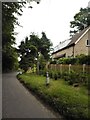
Verge by Horselees Road, Boughton-under-Blean
Image: © David Howard
Taken: 19 Jun 2016
0.14 miles

10
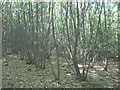
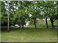
Coppice on the slopes of Iron Hill
A traditional form of woodland management.
Image: © Stephen Craven
Taken: 31 Aug 2009
0.17 miles