IMAGES TAKEN NEAR TO
North Lane, FAVERSHAM, ME13 9NJ
Introduction
This page details the photographs taken nearby to North Lane, ME13 9NJ by members of the Geograph project.
The Geograph project started in 2005 with the aim of publishing, organising and preserving representative images for every square kilometre of Great Britain, Ireland and the Isle of Man.

There are currently over 7.5m images from over14,400 individuals and you can help contribute to the project by visiting https://www.geograph.org.uk
Image Map
Images are licensed for reuse under creativecommons.org/licenses/by-sa/2.0
Notes
- Clicking on the map will re-center to the selected point.
- The higher the marker number, the further away the image location is from the centre of the postcode.
Image Listing (32 Images Found)
Images are licensed for reuse under creativecommons.org/licenses/by-sa/2.0
Image
Details
Distance
1
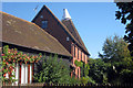
The Barn & Oast, North Lane, Boughton-under-blean, Kent
Image: © Oast House Archive
Taken: 22 Sep 2009
0.06 miles
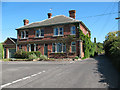
2
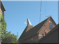
Former oast house on North Lane
The building is on a dead-end lane called North Lane, in the village of South Street.
Image: © Stephen Craven
Taken: 31 Aug 2009
0.07 miles
3
Lane off South Street
The building is one of many converted village public houses in East Kent.
Image: © pam fray
Taken: 20 Jan 2008
0.10 miles
4
Hop poles at South Street
This is probably the same field as Image two years earlier, it seems the local knowledge given to Jonathan was right.
Image: © Stephen Craven
Taken: 31 Aug 2009
0.10 miles
5
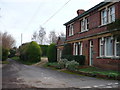
Junction of South Street and North Lane
South Street is both the name of the road in the foreground and of the hamlet itself.
Image: © Stephen Craven
Taken: 31 Aug 2009
0.11 miles
6
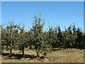
Apple orchard at South Street
The orchard is alongside the track shown on the map as India Street.
Image: © Stephen Craven
Taken: 31 Aug 2009
0.11 miles
7
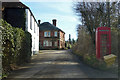
South Street
The building on the corner with North Lane was formerly the King's Arms pub.
Image: © Robin Webster
Taken: 8 Feb 2018
0.13 miles
8
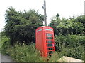
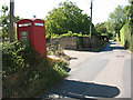
The leaning phonebox of South Street
This was erect in the 2009 Street View, and due to the lack of damage may be more of a foundation issue than being hit by a vehicle.
Image: © David Howard
Taken: 19 Jun 2016
0.14 miles
9
Telephone box at South Street
From this side the box appears vandalised and disused, but there was still a working phone in it.
Image: © Stephen Craven
Taken: 31 Aug 2009
0.14 miles
10
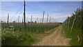
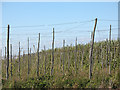
Kent Hop Fields
Hop fields with new crop of runners.
Image: © James Emmans
Taken: 16 May 2014
0.14 miles