IMAGES TAKEN NEAR TO
Hernhill, FAVERSHAM, ME13 9JU
Introduction
This page details the photographs taken nearby to ME13 9JU by members of the Geograph project.
The Geograph project started in 2005 with the aim of publishing, organising and preserving representative images for every square kilometre of Great Britain, Ireland and the Isle of Man.

There are currently over 7.5m images from over14,400 individuals and you can help contribute to the project by visiting https://www.geograph.org.uk
Image Map
Images are licensed for reuse under creativecommons.org/licenses/by-sa/2.0
Notes
- Clicking on the map will re-center to the selected point.
- The higher the marker number, the further away the image location is from the centre of the postcode.
Image Listing (58 Images Found)
Images are licensed for reuse under creativecommons.org/licenses/by-sa/2.0
Image
Details
Distance
1
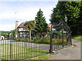
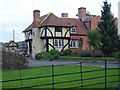
The Manor House at Hernhill
John Newman in The Buildings of England: North-East and East Kent says of Henhill: "The church is on the south side of a charming little green, a green that is all it should be, with an oak tree and a seat under it, and a path across the grass. Three characterful buildings on its north and east sides: the Red Lion Inn, a Wealden half-house, rendered a cream colour... and best of all, Manor House in the churchyard. This has a half-timbered cross-wing at the north end, overhanging three ways, a low linking part, and a brick block at the south end, battlemented to the west and painted white...."
Image: © Marathon
Taken: 6 Jul 2016
0.01 miles
2

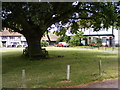
Village green, Hernhill
The large, half-timbered building on the left is the Red Lion pub (originally a Wealden Hall, built in 1364). There is a wooden plaque on the seat by the oak tree on the right which reads "This oak tree was planted by W E Gaskain Esq Chairman of the Hernhill Parish Council in commemoration of the Silver Jubilee of our gracious sovereign George V. May 6th 1935. H S Crole Rees Vicar."
The church of St Michael stands out of shot on the right.
Image: © Penny Mayes
Taken: 26 Feb 2007
0.01 miles
3
Shady Seat
The Village Green at Hernhill with the Red Lion Pub to the left.
Image: © Gordon Griffiths
Taken: 24 Jul 2009
0.01 miles
4
St. Michael's Church, Hernhill
Looking across the churchyard with Manor House on the right. Parish Church, 15th century, restored in 1867 and the nave restored 1877. It is a Grade I listed building. Manor House is Grade II* listed and dates from the 15th century and early 19th century.
Image: © pam fray
Taken: 25 Mar 2021
0.02 miles
5
Village Club, Hernhill
For more details of this building see Image The building on the left is the Red Lion, on the village green http://www.geograph.org.uk/photo/350242 .
Image: © Penny Mayes
Taken: 26 Feb 2007
0.02 miles
6
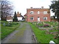
Manor House, Hernhill
What an extraordinary building. A small, half-timbered, jettied crosswing on a brick-built hall house with gothic windows, attached to which is a late 18th century south wing with fake battlements and brickwork reminiscent of dolls house wallpaper. This part of the building is used as the village club, founded by the Dawes family of Mount Ephraim, and one of the earliest in the country.
Image: © Penny Mayes
Taken: 26 Feb 2007
0.02 miles
7
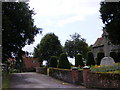
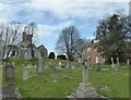
Hernhill Cross
The churchyard of St Michael's at Hernhill.
Image: © Gordon Griffiths
Taken: 24 Jul 2009
0.02 miles
8
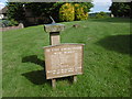
Memorial in Hernhill Churchyard
This simple recent memorial has no explanation but anyone visiting the tea room at nearby Mount Ephraim Gardens will find the explanation on the wall and several pictures of the event - see http://www.geograph.org.uk/photo/5029140
For further details and full accounts see https://en.wikipedia.org/wiki/Battle_of_Bossenden_Wood and http://hernhill.net/about-hernhill/battle-of-bossenden-wood/
Image: © Marathon
Taken: 6 Jul 2016
0.02 miles
9
St. Michael's Church, Hernhill
Viewed from Dawes Road.
Image: © pam fray
Taken: 25 Mar 2021
0.03 miles
10
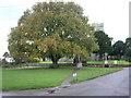
Oak tree at Hernhill
This beautiful tree was planted in commemoration of the Silver Jubilee of George V on May 6th, 1935.
Image: © pam fray
Taken: 21 Nov 2007
0.03 miles