IMAGES TAKEN NEAR TO
Dargate, FAVERSHAM, ME13 9HG
Introduction
This page details the photographs taken nearby to ME13 9HG by members of the Geograph project.
The Geograph project started in 2005 with the aim of publishing, organising and preserving representative images for every square kilometre of Great Britain, Ireland and the Isle of Man.

There are currently over 7.5m images from over14,400 individuals and you can help contribute to the project by visiting https://www.geograph.org.uk
Image Map
Images are licensed for reuse under creativecommons.org/licenses/by-sa/2.0
Notes
- Clicking on the map will re-center to the selected point.
- The higher the marker number, the further away the image location is from the centre of the postcode.
Image Listing (37 Images Found)
Images are licensed for reuse under creativecommons.org/licenses/by-sa/2.0
Image
Details
Distance
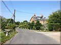
1
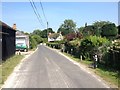
View along Butler's Hill from junction with Dargate Road
Image: © Nick Smith
Taken: 8 Apr 2008
0.02 miles
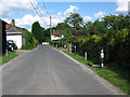
4
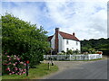
Cottage at Dargate
This is just along Butler's Hill from The Dove public house. Blean Wood is behind.
Image: © Marathon
Taken: 25 Jun 2022
0.03 miles
5
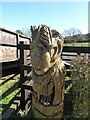
Wood carving, Dargate
In Red Road next to Elm Tree Cottage, Dargate
Image: © pam fray
Taken: 25 Mar 2021
0.05 miles
6
Wood carving, Dargate
Next to Elm Tree Cottage in Red Road.
Image: © pam fray
Taken: 25 Mar 2021
0.05 miles
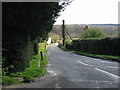
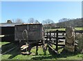
7
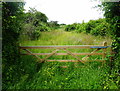
Gate in Butler's Hill
Obviously not often used judging by the grass and wild flowers growing through it.
Image: © pam fray
Taken: 11 Jun 2018
0.06 miles
8
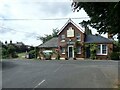
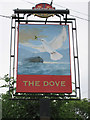
The Dove at Dargate
Like so many pubs in this area, The Dove is a Shepherd Neame pub.
Image: © Marathon
Taken: 25 Jun 2022
0.06 miles