IMAGES TAKEN NEAR TO
ME13 9GB
Introduction
This page details the photographs taken nearby to ME13 9GB by members of the Geograph project.
The Geograph project started in 2005 with the aim of publishing, organising and preserving representative images for every square kilometre of Great Britain, Ireland and the Isle of Man.

There are currently over 7.5m images from over14,400 individuals and you can help contribute to the project by visiting https://www.geograph.org.uk
Image Map
Images are licensed for reuse under creativecommons.org/licenses/by-sa/2.0
Notes
- Clicking on the map will re-center to the selected point.
- The higher the marker number, the further away the image location is from the centre of the postcode.
Image Listing (26 Images Found)
Images are licensed for reuse under creativecommons.org/licenses/by-sa/2.0
Image
Details
Distance
8
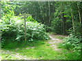
Three Bridleways and one footpath in Perry Wood
A bridleway from Grove Road, leads through Perry Wood and then becomes a footpath leading to Albox Wood. Another bridleway crosses, heading right to Grove Road, from a road near the Rose and Crown Pub.
Image: © David Anstiss
Taken: 24 Jun 2009
0.11 miles
10
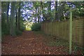
Bridleway in Perry Wood, near a fence
This bridleway leads from Grove Road westerly towards a junction with another bridleway. Fence is on edge of Cherry Tree Farm.
Image: © David Anstiss
Taken: 25 Oct 2009
0.14 miles