IMAGES TAKEN NEAR TO
Staple Street, FAVERSHAM, ME13 9FE
Introduction
This page details the photographs taken nearby to Staple Street, ME13 9FE by members of the Geograph project.
The Geograph project started in 2005 with the aim of publishing, organising and preserving representative images for every square kilometre of Great Britain, Ireland and the Isle of Man.

There are currently over 7.5m images from over14,400 individuals and you can help contribute to the project by visiting https://www.geograph.org.uk
Image Map
Images are licensed for reuse under creativecommons.org/licenses/by-sa/2.0
Notes
- Clicking on the map will re-center to the selected point.
- The higher the marker number, the further away the image location is from the centre of the postcode.
Image Listing (6 Images Found)
Images are licensed for reuse under creativecommons.org/licenses/by-sa/2.0
Image
Details
Distance
2
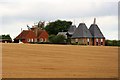
The Oast House, Fairbrook Farm, Hernhill, Kent
Image: © Oast House Archive
Taken: 9 May 2008
0.02 miles
3
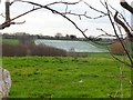
Strawberry field and Fairbrook Farm
Viewed across the valley from Kemsdale Road. These strawberries are growing under cloches, a common sight in this area, they look like water from a distance.
Image: © Penny Mayes
Taken: 26 Feb 2007
0.13 miles

5
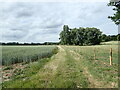
View from Staple Street
This is just west of Kemsdale Lodge. A footpath to the A299 follows the track ahead.
Image: © Marathon
Taken: 25 Jun 2022
0.23 miles
6
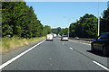
A299 Thanet Way towards Thanet
And also Whitstable and Herne Bay.
Image: © Robin Webster
Taken: 2 Jul 2018
0.25 miles