IMAGES TAKEN NEAR TO
Warm House Lane, FAVERSHAM, ME13 9DL
Introduction
This page details the photographs taken nearby to Warm House Lane, ME13 9DL by members of the Geograph project.
The Geograph project started in 2005 with the aim of publishing, organising and preserving representative images for every square kilometre of Great Britain, Ireland and the Isle of Man.

There are currently over 7.5m images from over14,400 individuals and you can help contribute to the project by visiting https://www.geograph.org.uk
Image Map
Images are licensed for reuse under creativecommons.org/licenses/by-sa/2.0
Notes
- Clicking on the map will re-center to the selected point.
- The higher the marker number, the further away the image location is from the centre of the postcode.
Image Listing (12 Images Found)
Images are licensed for reuse under creativecommons.org/licenses/by-sa/2.0
Image
Details
Distance
1
Sandbanks Lane, Graveney near Faversham
Sandbanks Lane forms part of National Cycle Network route 1, which links Dover with John o'Groats.
Image: © Malc McDonald
Taken: 26 Oct 2013
0.01 miles
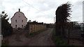
2
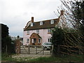
Sandbanks Court
On Sandbanks Road. This was known on maps as Sandbanks Cottages, now knocked into one house. But why the pink colour !!
Image: © David Anstiss
Taken: 10 Apr 2009
0.02 miles
3
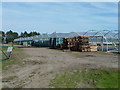
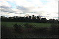
Polytunnels at Sandbanks Farm
Off Sandbanks Road.
Image: © Oast House Archive
Taken: 1 Sep 2010
0.05 miles
5

Strawberry growing in October - a modern method
These polytunnels at Sandbanks Farm look as if they hold strawberry trees. This method of growing extends the season and makes it easier for harvesting the crop. Photographed from Sandbanks Road.
Image: © pam fray
Taken: 20 Oct 2011
0.20 miles
6
Sandbanks Lane, near Faversham
The blue sign to the left of the road indicates that Sandbanks Lane forms part of National Cycle Network route 1, which links Dover with John o'Groats.
Image: © Malc McDonald
Taken: 26 Oct 2013
0.22 miles
7
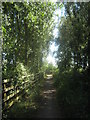
Cyclepath towards Nagden Cottages
National Cyclepath Route 1 leads from Faversham along the Faversham Creek towards a track to the Nagden Cottages, then it leads along Sandbanks towards Graveney.
Image: © David Anstiss
Taken: 10 Jul 2010
0.24 miles
8
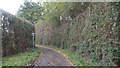
Cyclepath on Sandbanks Road
Cycle route 1 leaves Sandbanks Road from Graveney and then heads along a short track before joining the Saxon Shore Way (long distance path) on Seawall heading into Faversham.
Image: © David Anstiss
Taken: 10 Apr 2009
0.24 miles
9
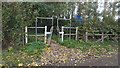
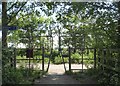
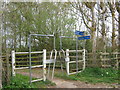
National Cycle Network near Faversham
The blue signs indicate that the path through the gateway forms part of National Cycle Network route 1, which links Dover with John o'Groats.
Image: © Malc McDonald
Taken: 26 Oct 2013
0.24 miles