IMAGES TAKEN NEAR TO
Brickfield Lane, FAVERSHAM, ME13 9AJ
Introduction
This page details the photographs taken nearby to Brickfield Lane, ME13 9AJ by members of the Geograph project.
The Geograph project started in 2005 with the aim of publishing, organising and preserving representative images for every square kilometre of Great Britain, Ireland and the Isle of Man.

There are currently over 7.5m images from over14,400 individuals and you can help contribute to the project by visiting https://www.geograph.org.uk
Image Map
Images are licensed for reuse under creativecommons.org/licenses/by-sa/2.0
Notes
- Clicking on the map will re-center to the selected point.
- The higher the marker number, the further away the image location is from the centre of the postcode.
Image Listing (31 Images Found)
Images are licensed for reuse under creativecommons.org/licenses/by-sa/2.0
Image
Details
Distance
1
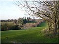
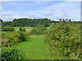
Boughton Golf Course taken from the "coffin track" footpath
Image: © pam fray
Taken: 27 Jan 2008
0.12 miles

3
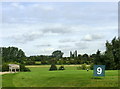
The 9th hole, Boughton Golf Course
Viewed from the footpath that leads from the village to the church of St. Peter and St. Paul on South Street.
Image: © pam fray
Taken: 3 Sep 2015
0.14 miles
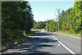
4
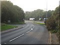
Junctions on Brickfield Lane
This lane from Boughton Street/ Neames Forstal is heading towards the A2 London Road dual carriageway, heading towards Faversham and M2 Motorway. The lane in front heading left, is Nine Ash Lane leading to Brenley Lane.
Image: © David Anstiss
Taken: 2 Jul 2009
0.14 miles
5
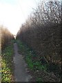
Footpath to Boughton Street, known as the coffin track
I am told that this footpath is the ancient track used by villagers to transport coffins from the main village to the church in Brenley Lane, over half a mile away. It now runs through Boughton Golf Course.
Image: © pam fray
Taken: 27 Jan 2008
0.15 miles
6
Boughton Golf Course, Boughton-under-Blean
Viewed from the footpath that leads from the village to the church of St. Peter and St. Paul on South Street.
Image: © pam fray
Taken: 3 Sep 2015
0.15 miles
8

Footpath from Boughton-under-Blean to South Street
The path crosses Boughton Golf Course and leads from the village to the parish church of St. Peter and St. Paul which is about a mile from the village centre.
Image: © pam fray
Taken: 3 Sep 2015
0.16 miles
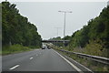
10
Road towards westbound A2
Still a two-way road here up to the junction with Nine Ash Lane.
Image: © Robin Webster
Taken: 2 Aug 2018
0.17 miles