IMAGES TAKEN NEAR TO
Graveney Road, FAVERSHAM, ME13 8UP
Introduction
This page details the photographs taken nearby to Graveney Road, ME13 8UP by members of the Geograph project.
The Geograph project started in 2005 with the aim of publishing, organising and preserving representative images for every square kilometre of Great Britain, Ireland and the Isle of Man.

There are currently over 7.5m images from over14,400 individuals and you can help contribute to the project by visiting https://www.geograph.org.uk
Image Map
Images are licensed for reuse under creativecommons.org/licenses/by-sa/2.0
Notes
- Clicking on the map will re-center to the selected point.
- The higher the marker number, the further away the image location is from the centre of the postcode.
Image Listing (25 Images Found)
Images are licensed for reuse under creativecommons.org/licenses/by-sa/2.0
Image
Details
Distance
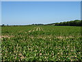
1
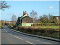
School Farm Cottages, Graveney Road
Rather oddly located, on the same side of the road and close to Ewell Farm, whereas School Farm is on the other side of the road.
Image: © Robin Webster
Taken: 9 Feb 2014
0.02 miles
6
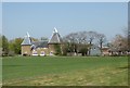
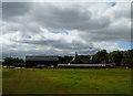
School Farm, Graveney
Viewed from Graveney Road.
Image: © pam fray
Taken: 21 Apr 2020
0.13 miles
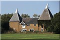
8
School Farm Oast, Graveney Road, Goodnestone, Kent
Image: © Oast House Archive
Taken: 11 Sep 2009
0.14 miles
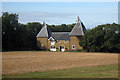
9
School Farm, Goodnestone
The oast is the home of the Kent Archaeological Field School.
Image: © pam fray
Taken: 6 Sep 2016
0.18 miles
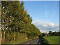
10
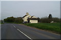
Cottage at the Homestall turning on the Faversham-Graveney road
Image: © David Long
Taken: 21 Apr 2006
0.19 miles