IMAGES TAKEN NEAR TO
St. Anns Road, FAVERSHAM, ME13 8RQ
Introduction
This page details the photographs taken nearby to St. Anns Road, ME13 8RQ by members of the Geograph project.
The Geograph project started in 2005 with the aim of publishing, organising and preserving representative images for every square kilometre of Great Britain, Ireland and the Isle of Man.

There are currently over 7.5m images from over14,400 individuals and you can help contribute to the project by visiting https://www.geograph.org.uk
Image Map
Images are licensed for reuse under creativecommons.org/licenses/by-sa/2.0
Notes
- Clicking on the map will re-center to the selected point.
- The higher the marker number, the further away the image location is from the centre of the postcode.
Image Listing (159 Images Found)
Images are licensed for reuse under creativecommons.org/licenses/by-sa/2.0
Image
Details
Distance
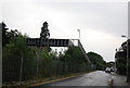
6
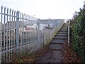
Footbridge over Railway
From Upper St Ann's road to St Ann's Road. Used to be a level crossing, but was too dangerous.
Image: © David Anstiss
Taken: 17 Jan 2009
0.04 miles