IMAGES TAKEN NEAR TO
School Road, FAVERSHAM, ME13 8QZ
Introduction
This page details the photographs taken nearby to School Road, ME13 8QZ by members of the Geograph project.
The Geograph project started in 2005 with the aim of publishing, organising and preserving representative images for every square kilometre of Great Britain, Ireland and the Isle of Man.

There are currently over 7.5m images from over14,400 individuals and you can help contribute to the project by visiting https://www.geograph.org.uk
Image Map
Images are licensed for reuse under creativecommons.org/licenses/by-sa/2.0
Notes
- Clicking on the map will re-center to the selected point.
- The higher the marker number, the further away the image location is from the centre of the postcode.
Image Listing (329 Images Found)
Images are licensed for reuse under creativecommons.org/licenses/by-sa/2.0
Image
Details
Distance
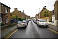
6
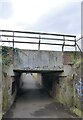
Subway under the railway line, Faversham
Running between School Road and Athelstan Road.
Image: © pam fray
Taken: 11 Apr 2021
0.03 miles
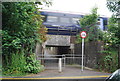
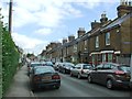
8
Railway over Footpath
Leads from Athelstan Road to School Road. Used mainly by schoolchildren to either Ethelbert Primary School (on Athelstan Road) or to The Abbey School or London Road A2.
Image: © David Anstiss
Taken: 17 Jan 2009
0.03 miles
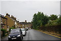
9
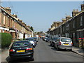
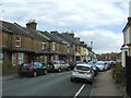
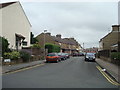
Plantation Road, Faversham
Plantation Road leads from School Road to South Road.
In the background above the road is the roof of Image
Image: © David Anstiss
Taken: 25 Apr 2011
0.04 miles