IMAGES TAKEN NEAR TO
Edward Vinson Drive, FAVERSHAM, ME13 8FF
Introduction
This page details the photographs taken nearby to Edward Vinson Drive, ME13 8FF by members of the Geograph project.
The Geograph project started in 2005 with the aim of publishing, organising and preserving representative images for every square kilometre of Great Britain, Ireland and the Isle of Man.

There are currently over 7.5m images from over14,400 individuals and you can help contribute to the project by visiting https://www.geograph.org.uk
Image Map
Images are licensed for reuse under creativecommons.org/licenses/by-sa/2.0
Notes
- Clicking on the map will re-center to the selected point.
- The higher the marker number, the further away the image location is from the centre of the postcode.
Image Listing (176 Images Found)
Images are licensed for reuse under creativecommons.org/licenses/by-sa/2.0
Image
Details
Distance
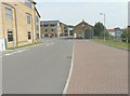
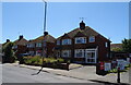
1
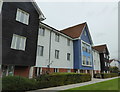
Kingsmead Care Home, off Edward Vinson Drive, Faversham
Part of a modern development. The road is named after a member of the local farming family who have farmed around Faversham since the 19th century.
Image: © pam fray
Taken: 14 Sep 2017
0.02 miles
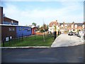
2
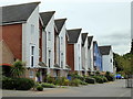
Houses in Thomas Neame Avenue, Faversham
Part of a modern development off Whitstable Road.
Image: © pam fray
Taken: 14 Sep 2017
0.03 miles
3
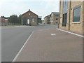
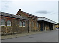
Looking south along Jubilee Way
Jubilee Way was formerly a railway goods yard and the building, in the centre of the view, was a goods station. Large doors at either end admitted railway wagons to an internal platform where goods were transferred by an iron loading crane. It was built in Faversham’s 19th century ‘vernacular’ of local yellow stock bricks highlighted with red brick dressings.http://www.faversham.org/history/favershams_railway_heritage.aspx
Image: © John Baker
Taken: 27 Jul 2014
0.05 miles
4
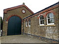
The Goods Shed, Faversham
In Jubilee Way, off Whitstable Road in a modern development of dwellings and commercial enterprises. The former goods shed to Faversham Station dates from circa 1858. It is a Grade II listed building and now houses CIM Online Ltd., publishers of magazines and newspapers.
Image: © pam fray
Taken: 14 Sep 2017
0.05 miles
5
The Goods Shed, Faversham
In Jubilee Way, off Whitstable Road in a modern development of dwellings and commercial enterprises. The former goods shed to Faversham Station dates from circa 1858. It is a Grade II listed building and now houses CIM Online Ltd., publishers of magazines and newspapers.
Image: © pam fray
Taken: 14 Sep 2017
0.06 miles
6
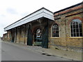
The Goods Shed, Faversham
In Jubilee Way, off Whitstable Road in a modern development of dwellings and commercial enterprises. The former goods shed to Faversham Station dates from circa 1858. It is a Grade II listed building and now houses CIM Online Ltd., publishers of magazines and newspapers.
Image: © pam fray
Taken: 14 Sep 2017
0.07 miles
7
Looking north along Jubilee Way
Jubilee Way was formerly a railway goods yard and the building, beyond the lamppost in the middle distance, was a goods station. Large doors at either end admitted railway wagons to an internal platform where goods were transferred by an iron loading crane. It was built in Faversham’s 19th century ‘vernacular’ of local yellow stock bricks highlighted with red brick dressings.http://www.faversham.org/history/favershams_railway_heritage.aspx
Image: © John Baker
Taken: 27 Jul 2014
0.07 miles
8
Queen Elizabeth II Jubilee Centre at Faversham
Image: © Elliott Simpson
Taken: 14 Nov 2008
0.07 miles
10
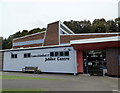
Queen Elizabeth II Jubilee Centre, Faversham
In Jubilee Way. It houses the Faversham Community Gymnastic and Activity Centre.
Image: © pam fray
Taken: 14 Sep 2017
0.09 miles