IMAGES TAKEN NEAR TO
Hidden Meadow, St. Anns Road, FAVERSHAM, ME13 8FA
Introduction
This page details the photographs taken nearby to Hidden Meadow, St. Anns Road, ME13 8FA by members of the Geograph project.
The Geograph project started in 2005 with the aim of publishing, organising and preserving representative images for every square kilometre of Great Britain, Ireland and the Isle of Man.

There are currently over 7.5m images from over14,400 individuals and you can help contribute to the project by visiting https://www.geograph.org.uk
Image Map
Images are licensed for reuse under creativecommons.org/licenses/by-sa/2.0
Notes
- Clicking on the map will re-center to the selected point.
- The higher the marker number, the further away the image location is from the centre of the postcode.
Image Listing (232 Images Found)
Images are licensed for reuse under creativecommons.org/licenses/by-sa/2.0
Image
Details
Distance
1
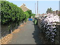
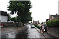
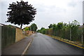
Pathway to Nightingale Road
This path leads from School Road.
On the left is a mass of Ivy and on the right is Clematis Montana var rubens.
Image: © David Anstiss
Taken: 25 Apr 2011
0.05 miles
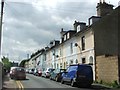
3
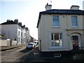
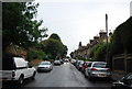
Nightingale Road, from South Road
The building in the foreground was a public house called St. Ann's Cross, which was named after the ancient cross which used to be here but was dismantled hundreds of years ago. The building is now a private dwelling.
Image: © pam fray
Taken: 6 Jan 2008
0.05 miles