IMAGES TAKEN NEAR TO
Preston Place, Chapel Street, FAVERSHAM, ME13 8ER
Introduction
This page details the photographs taken nearby to Preston Place, Chapel Street, ME13 8ER by members of the Geograph project.
The Geograph project started in 2005 with the aim of publishing, organising and preserving representative images for every square kilometre of Great Britain, Ireland and the Isle of Man.

There are currently over 7.5m images from over14,400 individuals and you can help contribute to the project by visiting https://www.geograph.org.uk
Image Map
Images are licensed for reuse under creativecommons.org/licenses/by-sa/2.0
Notes
- Clicking on the map will re-center to the selected point.
- The higher the marker number, the further away the image location is from the centre of the postcode.
Image Listing (573 Images Found)
Images are licensed for reuse under creativecommons.org/licenses/by-sa/2.0
Image
Details
Distance
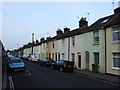
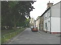
7
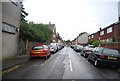
Houses on St John's Road, Faversham
Nearly all the near houses are pre-1865, according to a map of that date.
Image: © Robin Webster
Taken: 9 Feb 2014
0.03 miles
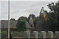
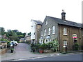
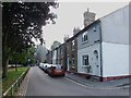
10
Looking south along Park Road
Towards the distinctive kilns and cowls of the former Preston Malthouse. These have been converted into private dwellings known as Upper Roundel and Lower Roundel. Faversham Recreation Ground is to the left.
Image: © John Baker
Taken: 27 Jul 2014
0.03 miles