IMAGES TAKEN NEAR TO
Century Road, FAVERSHAM, ME13 8DP
Introduction
This page details the photographs taken nearby to Century Road, ME13 8DP by members of the Geograph project.
The Geograph project started in 2005 with the aim of publishing, organising and preserving representative images for every square kilometre of Great Britain, Ireland and the Isle of Man.

There are currently over 7.5m images from over14,400 individuals and you can help contribute to the project by visiting https://www.geograph.org.uk
Image Map
Images are licensed for reuse under creativecommons.org/licenses/by-sa/2.0
Notes
- Clicking on the map will re-center to the selected point.
- The higher the marker number, the further away the image location is from the centre of the postcode.
Image Listing (147 Images Found)
Images are licensed for reuse under creativecommons.org/licenses/by-sa/2.0
Image
Details
Distance
6
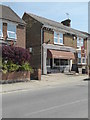
Temporary closure, Faversham
Fillers, once Burgate Bakery, a shop selling sandwiches and snacks, is one of many shops closed during the coronavirus pandemic. On Whitstable Road.
Image: © pam fray
Taken: 7 May 2020
0.04 miles
8
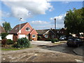
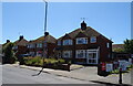
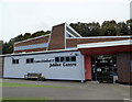
Queen Elizabeth II Jubilee Centre, Faversham
Community Gymnastic and Activity Centre.
Image: © JThomas
Taken: 22 Jun 2022
0.05 miles
9
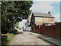
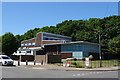
Looking west along Whitstable Road
This is where the former Faversham Quay Railway crossed the road and the “end” of the embankment can be seen on the left. This railway branched off from the main line just to the east of Faversham railway station. It was a freight only line that opened in April 1860 and closed in 1964. Today, it is known as Oyster Bay House. This is a grade II listed building that was built around 1843. It was originally used for storing hops prior to them being transported to London by barge, after which it was used by the United Fertilizer Company Ltd and the original signage can still be seen on both sides of the building. In the early 1990s, it was restored to provide accommodation over four floors with the ground floor being used as an office and the upper floors as living. This is the east side of the Image It seems fitting that there is a collection of old railway wagons nearby.
Image: © John Baker
Taken: 27 Jul 2014
0.05 miles
10
Queen Elizabeth II Jubilee Centre, Faversham
In Jubilee Way. It houses the Faversham Community Gymnastic and Activity Centre.
Image: © pam fray
Taken: 14 Sep 2017
0.06 miles