IMAGES TAKEN NEAR TO
Abbots Road, FAVERSHAM, ME13 8DE
Introduction
This page details the photographs taken nearby to Abbots Road, ME13 8DE by members of the Geograph project.
The Geograph project started in 2005 with the aim of publishing, organising and preserving representative images for every square kilometre of Great Britain, Ireland and the Isle of Man.

There are currently over 7.5m images from over14,400 individuals and you can help contribute to the project by visiting https://www.geograph.org.uk
Image Map
Images are licensed for reuse under creativecommons.org/licenses/by-sa/2.0
Notes
- Clicking on the map will re-center to the selected point.
- The higher the marker number, the further away the image location is from the centre of the postcode.
Image Listing (48 Images Found)
Images are licensed for reuse under creativecommons.org/licenses/by-sa/2.0
Image
Details
Distance
1
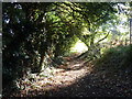
Footpath behind Abbotts Road, Faversham
Part of the Swale Heritage Trail.
Image: © pam fray
Taken: 20 Oct 2011
0.05 miles
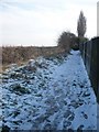
2
A section of the Swale Heritage Trail
This is the centre of the part that runs behind houses on Abbots Road.
Image: © pam fray
Taken: 4 Feb 2009
0.07 miles
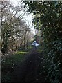
3
Footpath leading from Faversham to Goodnestone
Part of the Swale Heritage Trail
Image: © pam fray
Taken: 20 Oct 2011
0.08 miles
4
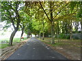
Path along the east side of Faversham Recreation Ground
The park was established in 1860. In 2018 the Heritage Lottery Fund agreed to fund a park improvement project to the value of £1.9m. The ongoing work includes improvement to paths, formal gardens, benches, refurbishing of buildings with a cafe kiosk and public WC. Already in place are perimeter railings, new play areas for various ages and an outdoor fitness area for adults. Sadly, work has been temporarily halted due to the coronavirus pandemic.
Image: © pam fray
Taken: 7 May 2020
0.09 miles
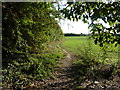
5
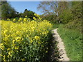
Footpath near Faversham
The path leads out of town into a rapeseed field and on to Goodnestone Court.
Image: © pam fray
Taken: 21 Apr 2020
0.10 miles
6
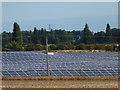
Solar Farm, Faversham
Abbey Fields solar array,Faversham. Developed by Farm Renewables, the 12.5ha site lies within an area of best and most versatile agricultural land. It was completed this year.
Image: © pam fray
Taken: 6 Sep 2016
0.10 miles
7

Play area, Faversham
In the recreation ground on the Millfield Estate. Abbots Road is in the background.
Image: © pam fray
Taken: 22 Sep 2023
0.10 miles
8
A section of the Swale Heritage Trail
Leaving the houses behind, the trail now heads towards a level crossing and, eventually, Goodnestone.
Image: © pam fray
Taken: 4 Feb 2009
0.11 miles
9
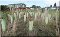
Recreation Ground, Faversham
On the Millfield Estate. New tree planting, wisely fenced off while they establish. Abbots Road is to the right and Arden Road to the left.
Image: © pam fray
Taken: 22 Sep 2023
0.13 miles
10
Part of the Swale Heritage Trail
This section runs behind the back gardens of Abbots Road.
Image: © pam fray
Taken: 4 Feb 2009
0.14 miles