IMAGES TAKEN NEAR TO
Belvedere Road, FAVERSHAM, ME13 7QL
Introduction
This page details the photographs taken nearby to Belvedere Road, ME13 7QL by members of the Geograph project.
The Geograph project started in 2005 with the aim of publishing, organising and preserving representative images for every square kilometre of Great Britain, Ireland and the Isle of Man.

There are currently over 7.5m images from over14,400 individuals and you can help contribute to the project by visiting https://www.geograph.org.uk
Image Map
Images are licensed for reuse under creativecommons.org/licenses/by-sa/2.0
Notes
- Clicking on the map will re-center to the selected point.
- The higher the marker number, the further away the image location is from the centre of the postcode.
Image Listing (1147 Images Found)
Images are licensed for reuse under creativecommons.org/licenses/by-sa/2.0
Image
Details
Distance
2
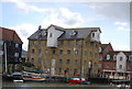
1-7 Provender
Grade II listed https://historicengland.org.uk/listing/the-list/list-entry/1069471 converted warehouse by Faversham Creek, off Belevedere Road. New a restaurant at ground floor and apartments above.
Image: © Oast House Archive
Taken: 3 Sep 2011
0.01 miles
3
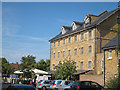
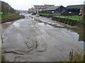
Belvedere Wharf
As seen from Belvedere Road. Many wharfs and buildings along this road have been truned into spacious flats and townhouses beside the Faversham Creek.
Image: © David Anstiss
Taken: 27 Feb 2010
0.01 miles
4
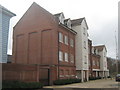
Sea Scout Headquarters - Faversham
Making good use of an ancient building.
Image: © Colin Babb
Taken: 9 Jul 2010
0.01 miles
6
Faversham Nautical Festival weekend
View of Faversham Creek from Swan Quay. The festival is a Kentish Sail Association event.
Image: © pam fray
Taken: 25 May 2013
0.02 miles
7
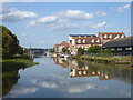
Faversham Creek at high tide
The late afternoon sun lights up Faversham Creek as seen from the swing bridge on Bridge Road. This was at high tide looking towards the estuary.
Image: © Marathon
Taken: 20 Aug 2019
0.02 miles
8
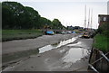
Faversham Creek at low tide
Seen from Bridge Road which is on the Saxon Shore Way, the latter continues on the left hand side of the creek out towards Ham Marshes.
Image: © Marathon
Taken: 16 Nov 2014
0.02 miles
9
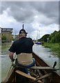
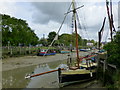
Up the creek without a paddle, Faversham
Approaching Town Quay and Bridge Road. I thought it prudent to just sit and enjoy the scenery rather than use the paddle. The craft is a half-size replica of a bronze age boat built using authentic tools and materials where possible. It is on the creek as part of the Nautical Festival. The building on the left has been converted for use as a restaurant.
Image: © pam fray
Taken: 13 Jul 2014
0.02 miles
10
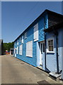
The Chandlery, off Belvedere Road, Faversham
Path leading to Swan Quay. In the distance is Faversham Creek and on the far side of that is Front Brents, which has stalls and amusements as part of the annual Nautical Festival. www.visitkent.co.uk/events/219113
Image: © pam fray
Taken: 23 Jul 2016
0.02 miles