IMAGES TAKEN NEAR TO
South Road, FAVERSHAM, ME13 7LZ
Introduction
This page details the photographs taken nearby to South Road, ME13 7LZ by members of the Geograph project.
The Geograph project started in 2005 with the aim of publishing, organising and preserving representative images for every square kilometre of Great Britain, Ireland and the Isle of Man.

There are currently over 7.5m images from over14,400 individuals and you can help contribute to the project by visiting https://www.geograph.org.uk
Image Map
Images are licensed for reuse under creativecommons.org/licenses/by-sa/2.0
Notes
- Clicking on the map will re-center to the selected point.
- The higher the marker number, the further away the image location is from the centre of the postcode.
Image Listing (221 Images Found)
Images are licensed for reuse under creativecommons.org/licenses/by-sa/2.0
Image
Details
Distance

2
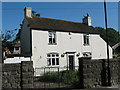
Gunsmoke Cottage
On South Road.
Close to Chart Gunpowder Mills.
Image: © David Anstiss
Taken: 21 May 2011
0.03 miles
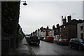
4
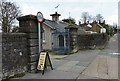
South Road, Faversham
This was the Home Works entrance to Chart Mill. As can be seen on the sign outside, it is now a local attraction, being a museum containing the remains of the incorporating mill, a scale model of the mill and much information on the history of the gunpowder industry in Faversham.
Image: © pam fray
Taken: 4 Apr 2010
0.04 miles
8
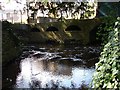
Redundant power source
This is the mill stream as it leaves Chart gunpowder mill and heads for Twymans Mill and Stonebridge Pond. It once powered several wheels here, used to grind materials for the gunpowder industry in Faversham.
Image: © Penny Mayes
Taken: 9 Apr 2007
0.05 miles
9
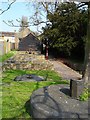
Chart gunpowder mill
A modest little building surrounded by modern housing estates, Chart mill once played a major part in Faversham's gunpowder industry. The first nationalised industry in the country, gunpowder made here helped fight the Napoleonic wars.
It was first established around 1560 but came under the control of the Government about 200 years later. There were two water wheels powering four mills. The edge running wheels seen here incorporated the raw materials; charcoal, sulphur and saltpetre.
Image: © Penny Mayes
Taken: 9 Apr 2007
0.05 miles
10
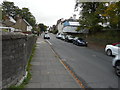
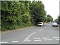
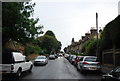
Looking east along South Road
The building on the right, encased in scaffolding and plastic sheeting, was undergoing renovation. It was subsequently given the name of Image
Image: © John Baker
Taken: 7 Oct 2015
0.06 miles