IMAGES TAKEN NEAR TO
Crescent Road, FAVERSHAM, ME13 7GU
Introduction
This page details the photographs taken nearby to Crescent Road, ME13 7GU by members of the Geograph project.
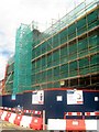
The Geograph project started in 2005 with the aim of publishing, organising and preserving representative images for every square kilometre of Great Britain, Ireland and the Isle of Man.

There are currently over 7.5m images from over14,400 individuals and you can help contribute to the project by visiting https://www.geograph.org.uk
Image Map
Images are licensed for reuse under creativecommons.org/licenses/by-sa/2.0
Notes
- Clicking on the map will re-center to the selected point.
- The higher the marker number, the further away the image location is from the centre of the postcode.
Image Listing (1282 Images Found)
Images are licensed for reuse under creativecommons.org/licenses/by-sa/2.0
Image
Details
Distance
1
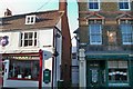
Streets Meeting Point - Faversham
Junction of Market St and East St.
Image: © Colin Babb
Taken: 9 Jul 2010
0.02 miles
2
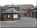
Where's the shelter?
The fact that this former brewery stable once served as an air raid shelter has been obscured by the unfortunate positioning of the Age Concern sign.
Image: © Mike Bremner
Taken: 6 Feb 2011
0.02 miles
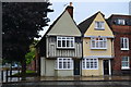
3
39 & 39a Court St
Grade II listed. http://www.britishlistedbuildings.co.uk/en-175901-39-and-39a-faversham
Image: © N Chadwick
Taken: 5 Jul 2011
0.02 miles
4
Changes to Faversham Tesco's
This building was a former Brewery, part of it now houses Tesco's supermarket.
The supermarket is now extending into the rest of the building, with expanded clothes, area, new cafe and new pharmacy.
Image: © David Anstiss
Taken: 21 Jul 2010
0.02 miles
5
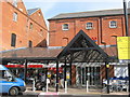
New entrance to Faversham Tesco's
This store on Crescent Road occupies the converted Fremlin's Brewery. It has recently undergone extension into more parts of the Brewery buildings. It now has a Costa Cafe, clothes section, pharmacy and a new entrance.
The old entrance is straight ahead (now the exit!). The entrance is to the left, through the former cafe area!
Image: © David Anstiss
Taken: 12 Mar 2011
0.02 miles
6
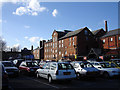
Old brewery, Faversham
The brewery was originally Rigden's, later Fremlin's and finally Whitbread's before closing towards the end of the 20th century. Much of the building now houses a large Tesco supermarket.
Image: © Penny Mayes
Taken: 1 Apr 2006
0.02 miles
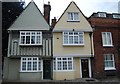
7
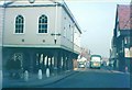
Town Hall, Faversham in 1968
Looking along Court Street from Market Place.
Image: © John Baker
Taken: Unknown
0.03 miles
8
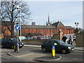
Faversham Tesco's Supermarket
As seen from the new pedestrian access on Crescent Road.
This store occupies the converted Fremlin's Brewery. It has recently undergone extension to more parts of the Brewery buildings. It now has a Costa Cafe, clothes section, pharmacy and a new entrance. The car park has also been altered.
The spire in the background, is Image
Image: © David Anstiss
Taken: 12 Mar 2011
0.03 miles
9
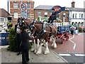
Shepherd Neame dray and horses
On the corner of Crescent Road, Court Street is in the background with its Shepherd Neame buildings. Part of Faversham Hop Festival celebrations.
Image: © pam fray
Taken: 4 Sep 2010
0.03 miles