IMAGES TAKEN NEAR TO
Moulder End, FAVERSHAM, ME13 7GJ
Introduction
This page details the photographs taken nearby to Moulder End, ME13 7GJ by members of the Geograph project.
The Geograph project started in 2005 with the aim of publishing, organising and preserving representative images for every square kilometre of Great Britain, Ireland and the Isle of Man.

There are currently over 7.5m images from over14,400 individuals and you can help contribute to the project by visiting https://www.geograph.org.uk
Image Map
Images are licensed for reuse under creativecommons.org/licenses/by-sa/2.0
Notes
- Clicking on the map will re-center to the selected point.
- The higher the marker number, the further away the image location is from the centre of the postcode.
Image Listing (55 Images Found)
Images are licensed for reuse under creativecommons.org/licenses/by-sa/2.0
Image
Details
Distance
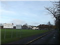
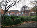
1
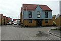
Breeze Meadow
Part of a housing estate, called Davington Fields.
Image: © John Baker
Taken: 1 Mar 2023
0.04 miles
2
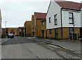
Breeze Meadow
Part of a housing estate, called Davington Fields.
Image: © John Baker
Taken: 1 Mar 2023
0.04 miles
3
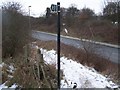
Footpath crosses B2045 Western Link Road
Path from Wildish Road, leads behind primary school, over rough ground, then over busy road (has many lorries on - due to industrial estate at Oare). Path then leads across field to Bysing Wood, on Bysing Wood Road. B2045 Link Road heads left to A2 London Road from Oare.
Image: © David Anstiss
Taken: 4 Feb 2009
0.08 miles
4
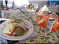
Traditional Xmas Day Lunch, Faversham
Within Kiln Court, the residents of the care home get a traditional Xmas Lunch.
Image: © David Anstiss
Taken: 25 Dec 2012
0.08 miles
5

Close up of Bearded Iris Flower
A close-up of Image
Image: © David Anstiss
Taken: 25 Apr 2011
0.09 miles
6
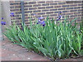
Bearded Irises at Kiln Court
Part of the gardens around the care home, tended by volunteers.
Image: © David Anstiss
Taken: 25 Apr 2011
0.09 miles
7
Bysing Wood Primary School, Faversham
At the end of Lower Road.
Also has a Sure Start Children's Centre.
Behind the school is a small woodland.
Image: © David Anstiss
Taken: 15 Dec 2012
0.09 miles
8
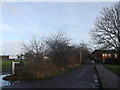
The end of Lower Road, Faversham
This long road (nearly a mile long) leads from Ospringe Road, through the suburbs of Ospringe.
On the left is Image
A footpath leads on to the Hazebrouck Road estate or Wildish Road.
Image: © David Anstiss
Taken: 15 Dec 2012
0.10 miles
9
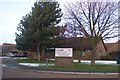
Kiln Court Residential Home
On Lower Road. A Social Services Care Home with 30 registered places. Has three units 'Abbey', 'Davington' and 'Ospringe' that take long and short time care of the elderly. Also has a day centre, where taxis bring visitors for lunch and afternoon activities.
Image: © David Anstiss
Taken: 17 Dec 2009
0.11 miles
10
View of Lewis Close, Faversham
As seen from Kiln Court.
Image: © David Anstiss
Taken: 25 Dec 2011
0.11 miles