IMAGES TAKEN NEAR TO
Seager Road, FAVERSHAM, ME13 7FD
Introduction
This page details the photographs taken nearby to Seager Road, ME13 7FD by members of the Geograph project.
The Geograph project started in 2005 with the aim of publishing, organising and preserving representative images for every square kilometre of Great Britain, Ireland and the Isle of Man.

There are currently over 7.5m images from over14,400 individuals and you can help contribute to the project by visiting https://www.geograph.org.uk
Image Map
Images are licensed for reuse under creativecommons.org/licenses/by-sa/2.0
Notes
- Clicking on the map will re-center to the selected point.
- The higher the marker number, the further away the image location is from the centre of the postcode.
Image Listing (140 Images Found)
Images are licensed for reuse under creativecommons.org/licenses/by-sa/2.0
Image
Details
Distance
1
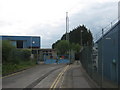
Closed Factory on Seager Road
This small road leads from Oare Road to this former steelworks Factory in Faversham. It has a mobile phone mast in its land. A footpath leads between the factory and the distribution centre for Marks and Spencer (on right) to Bysing Wood Road.
Image: © David Anstiss
Taken: 20 Jun 2009
0.03 miles
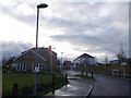
2

Lakeside Avenue, Oare
A modern, small housing development to the west of Oare Road.
Image: © pam fray
Taken: 27 Mar 2020
0.05 miles
3

Oare windmill
This was converted many years ago to a private home.
Image: © pam fray
Taken: 16 Nov 2007
0.07 miles
4

Lakeside Avenue, Davington Park
Davington Park is a mix of 1 and 2 bedroom apartments and 2, 3 and 4 bedroom homes being sold through Redrow Homes https://www.redrow.co.uk/tv/279-faversham-davington-park The first house on the left appears to be a show house for Redrow Homes.
Image: © John Baker
Taken: 24 Aug 2014
0.07 miles
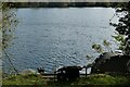
5

Fishing lake off Lakeside Avenue
The lake runs along the edge of the avenue and Oare Road. Seen from the footpath to the rear of Lakeside Avenue, a small, modern housing development.
Image: © pam fray
Taken: 17 Jan 2021
0.08 miles
6

Lakeside Avenue, Oare
A modern, small housing development to the west of Oare Road.
Image: © pam fray
Taken: 27 Mar 2020
0.08 miles
7
Davington Park, Oare
This new block of houses is beside Oare Road.
It was once the site of disused Warehouses. On the right, is the smaller modern Foundry Business Park.
Image: © David Anstiss
Taken: 25 Dec 2012
0.08 miles
8

View from a path through The Foundry Business Park
There are several enclosed paths around this distribution depot within The Foundry Business Park which mainly services Marks & Spencer. This is the view from a path leading to Oare Road. The entrance to the depot is on Oare Road. Being a Saturday afternoon there was less activity than usual.
Image: © Marathon
Taken: 1 Nov 2014
0.09 miles
9
Gone to lunch, Oare
The angler has just left his equipment, presumably for refreshment or other needs. The fishing lake is next to Lakeside Avenue, a small, modern housing development.
Image: © pam fray
Taken: 24 Oct 2021
0.09 miles
10

Fishing lake off Lakeside Avenue
The lake runs along the edge of the avenue and Oare Road. Seen from the footpath to the rear of Lakeside Avenue, a small, modern housing development.
Image: © pam fray
Taken: 17 Jan 2021
0.09 miles