IMAGES TAKEN NEAR TO
Church Street, FAVERSHAM, ME13 7BB
Introduction
This page details the photographs taken nearby to Church Street, ME13 7BB by members of the Geograph project.
The Geograph project started in 2005 with the aim of publishing, organising and preserving representative images for every square kilometre of Great Britain, Ireland and the Isle of Man.

There are currently over 7.5m images from over14,400 individuals and you can help contribute to the project by visiting https://www.geograph.org.uk
Image Map
Images are licensed for reuse under creativecommons.org/licenses/by-sa/2.0
Notes
- Clicking on the map will re-center to the selected point.
- The higher the marker number, the further away the image location is from the centre of the postcode.
Image Listing (1144 Images Found)
Images are licensed for reuse under creativecommons.org/licenses/by-sa/2.0
Image
Details
Distance
1
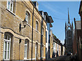
South Street
Terraced residential road leading to Church of St. Mary of Charity.
Image: © Oast House Archive
Taken: 3 Sep 2011
0.01 miles
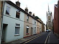
4
Church Street, Faversham
The road runs between St. Mary's church and Abbey Street, which can be seen at the far end together with Creek Creative Art Studio and Quay Lane. The conversion of a former Whitbread building, now apartments known as Old Brewery Lofts, is on the right.
Image: © pam fray
Taken: 15 Feb 2015
0.01 miles
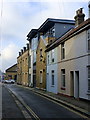
5
![Faversham buildings [5]](https://s0.geograph.org.uk/geophotos/07/07/54/7075428_2f6ec570_120x120.jpg)
Faversham buildings [5]
Behind the red brick wall in Church Street are various departments of the Fremlin's brewery - the carpenters shop, the coopers shop and the old cask yard. Built circa 1890 in red brick with slate and asbestos slate roofs. Listed, grade II, with details at: https://historicengland.org.uk/listing/the-list/list-entry/1240601
The Rigden brewery, founded in the early 18th century, became George Beer & Rigden before being purchased by Fremlin's. Whitbread bought out Fremlin's in 1967, and closed the Faversham brewery in 1990.
Faversham is a market town in Kent, some 41 miles southeast of London and 8½ miles west of Canterbury. Settlement goes back to the pre-Roman period. Kent is the centre of hop-growing in England and Faversham has been the home of several breweries, including the Shepherd Neame Brewery, founded in 1698. Faversham was the centre of the explosives industry between the 17th and early 20th century, before a decline following an accident in 1916 which killed over 100 workers.
Image: © Michael Dibb
Taken: 10 Sep 2021
0.01 miles
6
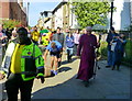
Rolling the barrel, Church Street, Faversham
Approaching the parish church, the traditional barrel rolling takes place for the Bishop of Dover, the Rt. Rev. Trevor Willmott, to 'Bless the Beer' at the church door before a special morning service. Part of Faversham Hop Festival which is in its 26th year.
Image: © pam fray
Taken: 6 Sep 2015
0.01 miles
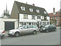
7
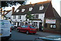
The Phoenix Tavern
Grade II listed. http://www.britishlistedbuildings.co.uk/en-175851-the-phoenix-public-house-faversham-kent
Image: © N Chadwick
Taken: 17 Jun 2014
0.02 miles
9
The Phoenix Tavern
Grade II listed. http://www.britishlistedbuildings.co.uk/en-175851-the-phoenix-public-house-faversham-kent
Image: © N Chadwick
Taken: 4 Nov 2012
0.02 miles
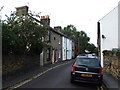
10
The Phoenix Tavern, Abbey Street, Faversham
Is next door to Image . The spire of St Mary of Charity can be seen to the left of the tavern.
Image: © John Baker
Taken: 8 Jan 2012
0.02 miles