IMAGES TAKEN NEAR TO
West View, FAVERSHAM, ME13 0LZ
Introduction
This page details the photographs taken nearby to West View, ME13 0LZ by members of the Geograph project.
The Geograph project started in 2005 with the aim of publishing, organising and preserving representative images for every square kilometre of Great Britain, Ireland and the Isle of Man.

There are currently over 7.5m images from over14,400 individuals and you can help contribute to the project by visiting https://www.geograph.org.uk
Image Map
Images are licensed for reuse under creativecommons.org/licenses/by-sa/2.0
Notes
- Clicking on the map will re-center to the selected point.
- The higher the marker number, the further away the image location is from the centre of the postcode.
Image Listing (20 Images Found)
Images are licensed for reuse under creativecommons.org/licenses/by-sa/2.0
Image
Details
Distance
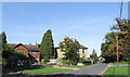
4
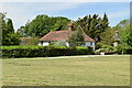
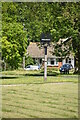
Sheldwich Lees
The unfenced road across Sheldwich Lees is bordered by woodland on the east side and by the cricket pitch on the west.
Image: © Penny Mayes
Taken: 1 Apr 2007
0.16 miles
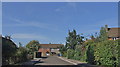
5
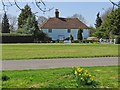
Across the village green at Sheldwich
One of the houses that line the western side of the green
Image: © Paul Harrop
Taken: 23 Apr 2013
0.17 miles
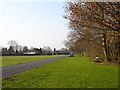
10
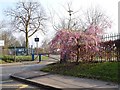
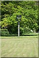
Sheldwich Primary School
A pretty flowering tree by the entrance - it seems a bit early for cherry, perhaps it's an ornamental plum?
Image: © Penny Mayes
Taken: 1 Apr 2007
0.19 miles